You are here: Home > Network List > TM - Thai Seismic Monitoring Network Stations List
> Station CMAI AngKang, ChiangMai > Earthquake Result Viewer
CMAI AngKang, ChiangMai - Earthquake Result Viewer
| Earthquake location: |
Hokkaido, Japan Region |
| Earthquake latitude/longitude: |
41.1/142.8 |
| Earthquake time(UTC): |
2023/03/28 (087) 09:18:27 GMT |
| Earthquake Depth: |
31 km |
| Earthquake Magnitude: |
6.2 Mww |
| Earthquake Catalog/Contributor: |
NEIC PDE/us |
|
| Network: |
TM Thai Seismic Monitoring Network |
| Station: |
CMAI AngKang, ChiangMai |
| Lat/Lon: |
19.93 N/99.05 E |
| Elevation: |
1544 m |
|
| Distance: |
42.7 deg |
| Az: |
253.76 deg |
| Baz: |
50.415 deg |
| Ray Param: |
0.07298678 |
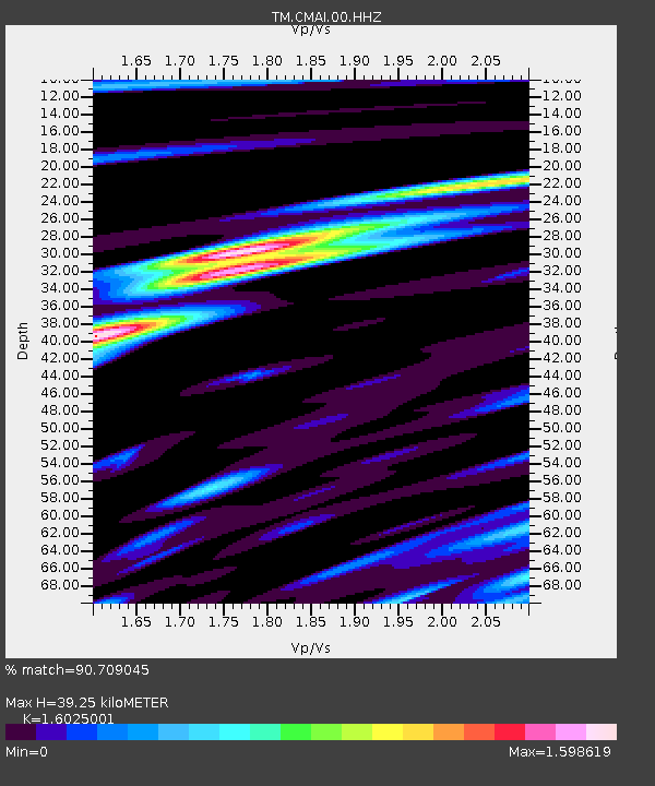
| Estimated Moho Depth: |
39.25 km |
| Estimated Crust Vp/Vs: |
1.60 |
| Assumed Crust Vp: |
6.35 km/s |
| Estimated Crust Vs: |
3.963 km/s |
| Estimated Crust Poisson's Ratio: |
0.18 |
|
| Radial Match: |
90.709045 % |
| Radial Bump: |
400 |
| Transverse Match: |
81.94588 % |
| Transverse Bump: |
400 |
| SOD ConfigId: |
30536071 |
| Insert Time: |
2023-04-11 09:45:40.978 +0000 |
| GWidth: |
2.5 |
| Max Bumps: |
400 |
| Tol: |
0.001 |
|

Signal To Noise
| Channel | StoN | STA | LTA |
| TM:CMAI:00:HHZ:20230328T09:25:50.909985Z | 34.276245 | 2.2528877E-6 | 6.572738E-8 |
| TM:CMAI:00:HHN:20230328T09:25:50.909985Z | 8.293722 | 1.0467227E-6 | 1.2620661E-7 |
| TM:CMAI:00:HHE:20230328T09:25:50.909985Z | 15.996661 | 1.1405161E-6 | 7.129714E-8 |
| Arrivals |
| Ps | 4.0 SECOND |
| PpPs | 15 SECOND |
| PsPs/PpSs | 19 SECOND |


