You are here: Home > Network List > TM - Thai Seismic Monitoring Network Stations List
> Station CHBT Khereethan Dam, Chanthaburi > Earthquake Result Viewer
CHBT Khereethan Dam, Chanthaburi - Earthquake Result Viewer
| Earthquake location: |
Hokkaido, Japan Region |
| Earthquake latitude/longitude: |
41.1/142.8 |
| Earthquake time(UTC): |
2023/03/28 (087) 09:18:27 GMT |
| Earthquake Depth: |
31 km |
| Earthquake Magnitude: |
6.2 Mww |
| Earthquake Catalog/Contributor: |
NEIC PDE/us |
|
| Network: |
TM Thai Seismic Monitoring Network |
| Station: |
CHBT Khereethan Dam, Chanthaburi |
| Lat/Lon: |
12.74 N/102.35 E |
| Elevation: |
198 m |
|
| Distance: |
45.2 deg |
| Az: |
243.097 deg |
| Baz: |
43.651 deg |
| Ray Param: |
0.07137021 |
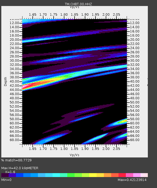
| Estimated Moho Depth: |
42.0 km |
| Estimated Crust Vp/Vs: |
1.60 |
| Assumed Crust Vp: |
6.498 km/s |
| Estimated Crust Vs: |
4.061 km/s |
| Estimated Crust Poisson's Ratio: |
0.18 |
|
| Radial Match: |
88.7729 % |
| Radial Bump: |
400 |
| Transverse Match: |
60.633446 % |
| Transverse Bump: |
400 |
| SOD ConfigId: |
30536071 |
| Insert Time: |
2023-04-11 09:45:41.183 +0000 |
| GWidth: |
2.5 |
| Max Bumps: |
400 |
| Tol: |
0.001 |
|

Signal To Noise
| Channel | StoN | STA | LTA |
| TM:CHBT:00:HHZ:20230328T09:26:11.379986Z | 7.2395287 | 1.8881884E-6 | 2.6081648E-7 |
| TM:CHBT:00:HHN:20230328T09:26:11.379986Z | 4.8676476 | 1.0612341E-6 | 2.1801785E-7 |
| TM:CHBT:00:HHE:20230328T09:26:11.379986Z | 5.9673758 | 1.2260575E-6 | 2.0546008E-7 |
| Arrivals |
| Ps | 4.2 SECOND |
| PpPs | 16 SECOND |
| PsPs/PpSs | 20 SECOND |


