You are here: Home > Network List > TA - USArray Transportable Network (new EarthScope stations) Stations List
> Station Y23A Lovelace Mesa, Carrizozo, NM, USA > Earthquake Result Viewer
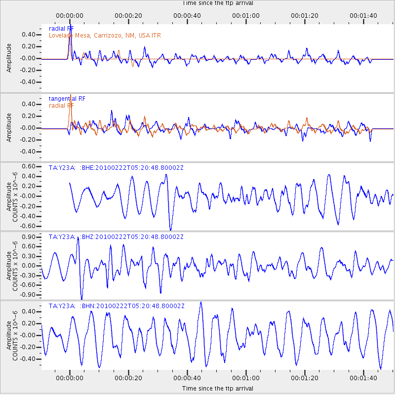
Y23A Lovelace Mesa, Carrizozo, NM, USA - Earthquake Result Viewer
*The percent match for this event was below the threshold and hence no stack was calculated.
| Earthquake location: |
Tonga Islands |
| Earthquake latitude/longitude: |
-21.5/-173.8 |
| Earthquake time(UTC): |
2010/02/22 (053) 05:08:49 GMT |
| Earthquake Depth: |
33 km |
| Earthquake Magnitude: |
5.8 MB, 5.3 MS, 5.7 MW, 5.7 MW |
| Earthquake Catalog/Contributor: |
WHDF/NEIC |
|
| Network: |
TA USArray Transportable Network (new EarthScope stations) |
| Station: |
Y23A Lovelace Mesa, Carrizozo, NM, USA |
| Lat/Lon: |
33.93 N/106.05 W |
| Elevation: |
1789 m |
|
| Distance: |
84.8 deg |
| Az: |
50.586 deg |
| Baz: |
239.913 deg |
| Ray Param: |
$rayparam |
*The percent match for this event was below the threshold and hence was not used in the summary stack. |
|
| Radial Match: |
70.662186 % |
| Radial Bump: |
358 |
| Transverse Match: |
62.26028 % |
| Transverse Bump: |
349 |
| SOD ConfigId: |
307546 |
| Insert Time: |
2010-05-14 06:47:32.730 +0000 |
| GWidth: |
2.5 |
| Max Bumps: |
400 |
| Tol: |
0.001 |
|
Signal To Noise
| Channel | StoN | STA | LTA |
| TA:Y23A: :BHZ:20100222T05:20:48.80002Z | 3.0232656 | 5.168356E-7 | 1.7095275E-7 |
| TA:Y23A: :BHN:20100222T05:20:48.80002Z | 1.3463348 | 2.6042068E-7 | 1.9342937E-7 |
| TA:Y23A: :BHE:20100222T05:20:48.80002Z | 1.8521446 | 3.5550747E-7 | 1.9194368E-7 |
| Arrivals |
| Ps | |
| PpPs | |
| PsPs/PpSs | |


