You are here: Home > Network List > TA - USArray Transportable Network (new EarthScope stations) Stations List
> Station W25A X Bar L Ranch, Newkirk, NM, USA > Earthquake Result Viewer
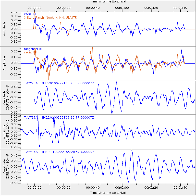
W25A X Bar L Ranch, Newkirk, NM, USA - Earthquake Result Viewer
*The percent match for this event was below the threshold and hence no stack was calculated.
| Earthquake location: |
Tonga Islands |
| Earthquake latitude/longitude: |
-21.5/-173.8 |
| Earthquake time(UTC): |
2010/02/22 (053) 05:08:49 GMT |
| Earthquake Depth: |
33 km |
| Earthquake Magnitude: |
5.8 MB, 5.3 MS, 5.7 MW, 5.7 MW |
| Earthquake Catalog/Contributor: |
WHDF/NEIC |
|
| Network: |
TA USArray Transportable Network (new EarthScope stations) |
| Station: |
W25A X Bar L Ranch, Newkirk, NM, USA |
| Lat/Lon: |
35.22 N/104.46 W |
| Elevation: |
1446 m |
|
| Distance: |
86.6 deg |
| Az: |
50.121 deg |
| Baz: |
240.779 deg |
| Ray Param: |
$rayparam |
*The percent match for this event was below the threshold and hence was not used in the summary stack. |
|
| Radial Match: |
73.02549 % |
| Radial Bump: |
397 |
| Transverse Match: |
57.816727 % |
| Transverse Bump: |
305 |
| SOD ConfigId: |
307546 |
| Insert Time: |
2010-05-14 06:48:16.986 +0000 |
| GWidth: |
2.5 |
| Max Bumps: |
400 |
| Tol: |
0.001 |
|
Signal To Noise
| Channel | StoN | STA | LTA |
| TA:W25A: :BHZ:20100222T05:20:57.600007Z | 3.5093355 | 5.780799E-7 | 1.6472632E-7 |
| TA:W25A: :BHN:20100222T05:20:57.600007Z | 0.4137049 | 1.037576E-7 | 2.5080098E-7 |
| TA:W25A: :BHE:20100222T05:20:57.600007Z | 0.5833206 | 1.2764474E-7 | 2.1882431E-7 |
| Arrivals |
| Ps | |
| PpPs | |
| PsPs/PpSs | |


