You are here: Home > Network List > IU - Global Seismograph Network (GSN - IRIS/USGS) Stations List
> Station JOHN Johnston Island, USA > Earthquake Result Viewer
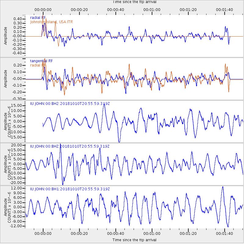
JOHN Johnston Island, USA - Earthquake Result Viewer
*The percent match for this event was below the threshold and hence no stack was calculated.
| Earthquake location: |
New Britain Region, P.N.G. |
| Earthquake latitude/longitude: |
-5.9/151.4 |
| Earthquake time(UTC): |
2018/10/10 (283) 20:48:20 GMT |
| Earthquake Depth: |
33 km |
| Earthquake Magnitude: |
7.3 Mi |
| Earthquake Catalog/Contributor: |
NEIC PDE/at |
|
| Network: |
IU Global Seismograph Network (GSN - IRIS/USGS) |
| Station: |
JOHN Johnston Island, USA |
| Lat/Lon: |
16.73 N/169.53 W |
| Elevation: |
2.0 m |
|
| Distance: |
44.7 deg |
| Az: |
59.158 deg |
| Baz: |
243.046 deg |
| Ray Param: |
$rayparam |
*The percent match for this event was below the threshold and hence was not used in the summary stack. |
|
| Radial Match: |
47.15665 % |
| Radial Bump: |
400 |
| Transverse Match: |
53.50948 % |
| Transverse Bump: |
395 |
| SOD ConfigId: |
3045211 |
| Insert Time: |
2018-10-24 20:56:39.407 +0000 |
| GWidth: |
2.5 |
| Max Bumps: |
400 |
| Tol: |
0.001 |
|
Signal To Noise
| Channel | StoN | STA | LTA |
| IU:JOHN:00:BHZ:20181010T20:55:59.319Z | 1.2325308 | 5.8169276E-6 | 4.719499E-6 |
| IU:JOHN:00:BH1:20181010T20:55:59.319Z | 1.0007542 | 3.540816E-6 | 3.5381472E-6 |
| IU:JOHN:00:BH2:20181010T20:55:59.319Z | 2.5173585 | 9.251798E-6 | 3.6752008E-6 |
| Arrivals |
| Ps | |
| PpPs | |
| PsPs/PpSs | |


