You are here: Home > Network List > IU - Global Seismograph Network (GSN - IRIS/USGS) Stations List
> Station MA2 Magadan, Russia > Earthquake Result Viewer
MA2 Magadan, Russia - Earthquake Result Viewer

| Earthquake location: |
New Britain Region, P.N.G. |
| Earthquake latitude/longitude: |
-5.9/151.4 |
| Earthquake time(UTC): |
2018/10/10 (283) 20:48:20 GMT |
| Earthquake Depth: |
33 km |
| Earthquake Magnitude: |
7.3 Mi |
| Earthquake Catalog/Contributor: |
NEIC PDE/at |
|
| Network: |
IU Global Seismograph Network (GSN - IRIS/USGS) |
| Station: |
MA2 Magadan, Russia |
| Lat/Lon: |
59.58 N/150.77 E |
| Elevation: |
339 m |
|
| Distance: |
65.3 deg |
| Az: |
359.647 deg |
| Baz: |
179.31 deg |
| Ray Param: |
0.058329135 |
| Estimated Moho Depth: |
28.5 km |
| Estimated Crust Vp/Vs: |
1.84 |
| Assumed Crust Vp: |
6.134 km/s |
| Estimated Crust Vs: |
3.329 km/s |
| Estimated Crust Poisson's Ratio: |
0.29 |
|
| Radial Match: |
97.64097 % |
| Radial Bump: |
386 |
| Transverse Match: |
83.88706 % |
| Transverse Bump: |
400 |
| SOD ConfigId: |
3045211 |
| Insert Time: |
2018-10-24 20:56:40.637 +0000 |
| GWidth: |
2.5 |
| Max Bumps: |
400 |
| Tol: |
0.001 |
|
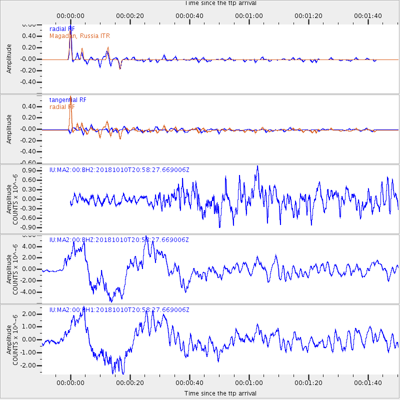
Signal To Noise
| Channel | StoN | STA | LTA |
| IU:MA2:00:BHZ:20181010T20:58:27.669006Z | 21.693819 | 3.6429653E-6 | 1.6792642E-7 |
| IU:MA2:00:BH1:20181010T20:58:27.669006Z | 14.829832 | 1.7587679E-6 | 1.1859661E-7 |
| IU:MA2:00:BH2:20181010T20:58:27.669006Z | 1.514238 | 1.4643224E-7 | 9.670359E-8 |
| Arrivals |
| Ps | 4.1 SECOND |
| PpPs | 13 SECOND |
| PsPs/PpSs | 17 SECOND |


