You are here: Home > Network List > TA - USArray Transportable Network (new EarthScope stations) Stations List
> Station R26A Arlington, CO, USA > Earthquake Result Viewer
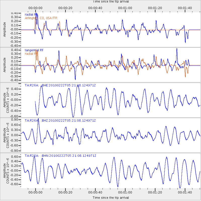
R26A Arlington, CO, USA - Earthquake Result Viewer
*The percent match for this event was below the threshold and hence no stack was calculated.
| Earthquake location: |
Tonga Islands |
| Earthquake latitude/longitude: |
-21.5/-173.8 |
| Earthquake time(UTC): |
2010/02/22 (053) 05:08:49 GMT |
| Earthquake Depth: |
33 km |
| Earthquake Magnitude: |
5.8 MB, 5.3 MS, 5.7 MW, 5.7 MW |
| Earthquake Catalog/Contributor: |
WHDF/NEIC |
|
| Network: |
TA USArray Transportable Network (new EarthScope stations) |
| Station: |
R26A Arlington, CO, USA |
| Lat/Lon: |
38.30 N/103.45 W |
| Elevation: |
1304 m |
|
| Distance: |
88.8 deg |
| Az: |
47.821 deg |
| Baz: |
241.289 deg |
| Ray Param: |
$rayparam |
*The percent match for this event was below the threshold and hence was not used in the summary stack. |
|
| Radial Match: |
58.452904 % |
| Radial Bump: |
400 |
| Transverse Match: |
54.89526 % |
| Transverse Bump: |
313 |
| SOD ConfigId: |
307546 |
| Insert Time: |
2010-05-14 06:51:46.911 +0000 |
| GWidth: |
2.5 |
| Max Bumps: |
400 |
| Tol: |
0.001 |
|
Signal To Noise
| Channel | StoN | STA | LTA |
| TA:R26A: :BHZ:20100222T05:21:08.124971Z | 2.806265 | 4.6893743E-7 | 1.6710375E-7 |
| TA:R26A: :BHN:20100222T05:21:08.124971Z | 0.8918366 | 4.4117903E-7 | 4.9468593E-7 |
| TA:R26A: :BHE:20100222T05:21:08.124971Z | 1.1568047 | 3.0435584E-7 | 2.6310045E-7 |
| Arrivals |
| Ps | |
| PpPs | |
| PsPs/PpSs | |


