You are here: Home > Network List > TA - USArray Transportable Network (new EarthScope stations) Stations List
> Station X28A Dimmitt, TX, USA > Earthquake Result Viewer
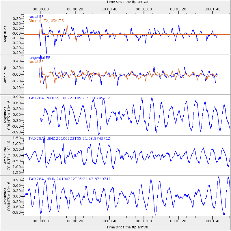
X28A Dimmitt, TX, USA - Earthquake Result Viewer
*The percent match for this event was below the threshold and hence no stack was calculated.
| Earthquake location: |
Tonga Islands |
| Earthquake latitude/longitude: |
-21.5/-173.8 |
| Earthquake time(UTC): |
2010/02/22 (053) 05:08:49 GMT |
| Earthquake Depth: |
33 km |
| Earthquake Magnitude: |
5.8 MB, 5.3 MS, 5.7 MW, 5.7 MW |
| Earthquake Catalog/Contributor: |
WHDF/NEIC |
|
| Network: |
TA USArray Transportable Network (new EarthScope stations) |
| Station: |
X28A Dimmitt, TX, USA |
| Lat/Lon: |
34.52 N/102.20 W |
| Elevation: |
1160 m |
|
| Distance: |
87.9 deg |
| Az: |
51.624 deg |
| Baz: |
242.14 deg |
| Ray Param: |
$rayparam |
*The percent match for this event was below the threshold and hence was not used in the summary stack. |
|
| Radial Match: |
70.775604 % |
| Radial Bump: |
400 |
| Transverse Match: |
62.41729 % |
| Transverse Bump: |
318 |
| SOD ConfigId: |
307546 |
| Insert Time: |
2010-05-14 06:52:29.320 +0000 |
| GWidth: |
2.5 |
| Max Bumps: |
400 |
| Tol: |
0.001 |
|
Signal To Noise
| Channel | StoN | STA | LTA |
| TA:X28A: :BHZ:20100222T05:21:03.874971Z | 2.9691393 | 7.8049663E-7 | 2.6286966E-7 |
| TA:X28A: :BHN:20100222T05:21:03.874971Z | 2.498933 | 6.102967E-7 | 2.442229E-7 |
| TA:X28A: :BHE:20100222T05:21:03.874971Z | 1.9304264 | 6.288565E-7 | 3.2576042E-7 |
| Arrivals |
| Ps | |
| PpPs | |
| PsPs/PpSs | |


