You are here: Home > Network List > AK - Alaska Regional Network Stations List
> Station D20K Etivluk River, AK, USA > Earthquake Result Viewer
D20K Etivluk River, AK, USA - Earthquake Result Viewer
| Earthquake location: |
New Guinea, Papua New Guinea |
| Earthquake latitude/longitude: |
-4.3/143.2 |
| Earthquake time(UTC): |
2023/04/02 (092) 18:04:12 GMT |
| Earthquake Depth: |
74 km |
| Earthquake Magnitude: |
7.3 Mi |
| Earthquake Catalog/Contributor: |
NEIC PDE/pt |
|
| Network: |
AK Alaska Regional Network |
| Station: |
D20K Etivluk River, AK, USA |
| Lat/Lon: |
68.71 N/156.61 W |
| Elevation: |
577 m |
|
| Distance: |
83.6 deg |
| Az: |
18.591 deg |
| Baz: |
240.528 deg |
| Ray Param: |
0.04590812 |
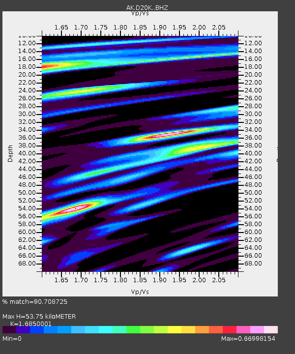
| Estimated Moho Depth: |
53.75 km |
| Estimated Crust Vp/Vs: |
1.69 |
| Assumed Crust Vp: |
6.221 km/s |
| Estimated Crust Vs: |
3.692 km/s |
| Estimated Crust Poisson's Ratio: |
0.23 |
|
| Radial Match: |
90.708725 % |
| Radial Bump: |
400 |
| Transverse Match: |
83.0722 % |
| Transverse Bump: |
400 |
| SOD ConfigId: |
30536071 |
| Insert Time: |
2023-04-16 18:06:45.368 +0000 |
| GWidth: |
2.5 |
| Max Bumps: |
400 |
| Tol: |
0.001 |
|

Signal To Noise
| Channel | StoN | STA | LTA |
| AK:D20K: :BHZ:20230402T18:16:01.219971Z | 76.90793 | 6.5819886E-6 | 8.5582705E-8 |
| AK:D20K: :BHN:20230402T18:16:01.219971Z | 5.654518 | 7.8070894E-7 | 1.3806817E-7 |
| AK:D20K: :BHE:20230402T18:16:01.219971Z | 21.554895 | 1.9743547E-6 | 9.1596576E-8 |
| Arrivals |
| Ps | 6.1 SECOND |
| PpPs | 23 SECOND |
| PsPs/PpSs | 29 SECOND |


