You are here: Home > Network List > TA - USArray Transportable Network (new EarthScope stations) Stations List
> Station 431A Sonora, TX, USA > Earthquake Result Viewer
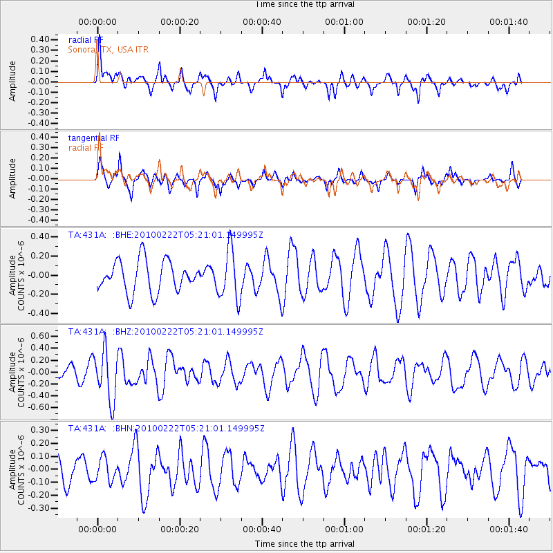
431A Sonora, TX, USA - Earthquake Result Viewer
*The percent match for this event was below the threshold and hence no stack was calculated.
| Earthquake location: |
Tonga Islands |
| Earthquake latitude/longitude: |
-21.5/-173.8 |
| Earthquake time(UTC): |
2010/02/22 (053) 05:08:49 GMT |
| Earthquake Depth: |
33 km |
| Earthquake Magnitude: |
5.8 MB, 5.3 MS, 5.7 MW, 5.7 MW |
| Earthquake Catalog/Contributor: |
WHDF/NEIC |
|
| Network: |
TA USArray Transportable Network (new EarthScope stations) |
| Station: |
431A Sonora, TX, USA |
| Lat/Lon: |
30.68 N/100.61 W |
| Elevation: |
700 m |
|
| Distance: |
87.3 deg |
| Az: |
55.642 deg |
| Baz: |
243.163 deg |
| Ray Param: |
$rayparam |
*The percent match for this event was below the threshold and hence was not used in the summary stack. |
|
| Radial Match: |
55.59365 % |
| Radial Bump: |
395 |
| Transverse Match: |
54.17096 % |
| Transverse Bump: |
287 |
| SOD ConfigId: |
307546 |
| Insert Time: |
2010-05-14 06:53:42.124 +0000 |
| GWidth: |
2.5 |
| Max Bumps: |
400 |
| Tol: |
0.001 |
|
Signal To Noise
| Channel | StoN | STA | LTA |
| TA:431A: :BHZ:20100222T05:21:01.149995Z | 2.9631379 | 4.3062056E-7 | 1.4532586E-7 |
| TA:431A: :BHN:20100222T05:21:01.149995Z | 0.63496387 | 8.948391E-8 | 1.4092755E-7 |
| TA:431A: :BHE:20100222T05:21:01.149995Z | 1.6406147 | 2.6885198E-7 | 1.6387271E-7 |
| Arrivals |
| Ps | |
| PpPs | |
| PsPs/PpSs | |


