You are here: Home > Network List > TA - USArray Transportable Network (new EarthScope stations) Stations List
> Station 532A Rocksprings, TX, USA > Earthquake Result Viewer
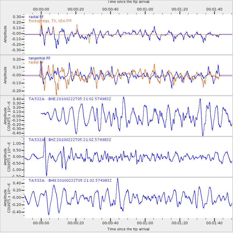
532A Rocksprings, TX, USA - Earthquake Result Viewer
*The percent match for this event was below the threshold and hence no stack was calculated.
| Earthquake location: |
Tonga Islands |
| Earthquake latitude/longitude: |
-21.5/-173.8 |
| Earthquake time(UTC): |
2010/02/22 (053) 05:08:49 GMT |
| Earthquake Depth: |
33 km |
| Earthquake Magnitude: |
5.8 MB, 5.3 MS, 5.7 MW, 5.7 MW |
| Earthquake Catalog/Contributor: |
WHDF/NEIC |
|
| Network: |
TA USArray Transportable Network (new EarthScope stations) |
| Station: |
532A Rocksprings, TX, USA |
| Lat/Lon: |
30.13 N/99.90 W |
| Elevation: |
703 m |
|
| Distance: |
87.6 deg |
| Az: |
56.409 deg |
| Baz: |
243.551 deg |
| Ray Param: |
$rayparam |
*The percent match for this event was below the threshold and hence was not used in the summary stack. |
|
| Radial Match: |
70.93818 % |
| Radial Bump: |
400 |
| Transverse Match: |
61.060135 % |
| Transverse Bump: |
342 |
| SOD ConfigId: |
307546 |
| Insert Time: |
2010-05-14 06:53:58.880 +0000 |
| GWidth: |
2.5 |
| Max Bumps: |
400 |
| Tol: |
0.001 |
|
Signal To Noise
| Channel | StoN | STA | LTA |
| TA:532A: :BHZ:20100222T05:21:02.574983Z | 4.802968 | 6.696702E-7 | 1.3942841E-7 |
| TA:532A: :BHN:20100222T05:21:02.574983Z | 2.612793 | 2.0411854E-7 | 7.812274E-8 |
| TA:532A: :BHE:20100222T05:21:02.574983Z | 1.3265902 | 2.0089037E-7 | 1.5143362E-7 |
| Arrivals |
| Ps | |
| PpPs | |
| PsPs/PpSs | |


