You are here: Home > Network List > TA - USArray Transportable Network (new EarthScope stations) Stations List
> Station 331A San Angelo, TX, USA > Earthquake Result Viewer
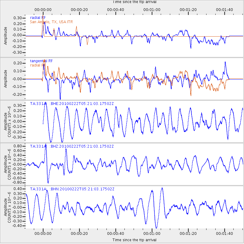
331A San Angelo, TX, USA - Earthquake Result Viewer
*The percent match for this event was below the threshold and hence no stack was calculated.
| Earthquake location: |
Tonga Islands |
| Earthquake latitude/longitude: |
-21.5/-173.8 |
| Earthquake time(UTC): |
2010/02/22 (053) 05:08:49 GMT |
| Earthquake Depth: |
33 km |
| Earthquake Magnitude: |
5.8 MB, 5.3 MS, 5.7 MW, 5.7 MW |
| Earthquake Catalog/Contributor: |
WHDF/NEIC |
|
| Network: |
TA USArray Transportable Network (new EarthScope stations) |
| Station: |
331A San Angelo, TX, USA |
| Lat/Lon: |
31.31 N/100.43 W |
| Elevation: |
615 m |
|
| Distance: |
87.7 deg |
| Az: |
55.155 deg |
| Baz: |
243.234 deg |
| Ray Param: |
$rayparam |
*The percent match for this event was below the threshold and hence was not used in the summary stack. |
|
| Radial Match: |
44.350426 % |
| Radial Bump: |
400 |
| Transverse Match: |
53.00748 % |
| Transverse Bump: |
318 |
| SOD ConfigId: |
307546 |
| Insert Time: |
2010-05-14 06:54:41.474 +0000 |
| GWidth: |
2.5 |
| Max Bumps: |
400 |
| Tol: |
0.001 |
|
Signal To Noise
| Channel | StoN | STA | LTA |
| TA:331A: :BHZ:20100222T05:21:03.17502Z | 3.9527593 | 4.3710833E-7 | 1.1058309E-7 |
| TA:331A: :BHN:20100222T05:21:03.17502Z | 1.4880285 | 2.2516457E-7 | 1.5131738E-7 |
| TA:331A: :BHE:20100222T05:21:03.17502Z | 0.60547316 | 1.3062855E-7 | 2.1574623E-7 |
| Arrivals |
| Ps | |
| PpPs | |
| PsPs/PpSs | |


