You are here: Home > Network List > TA - USArray Transportable Network (new EarthScope stations) Stations List
> Station H28A Mission Ridge, SD, USA > Earthquake Result Viewer
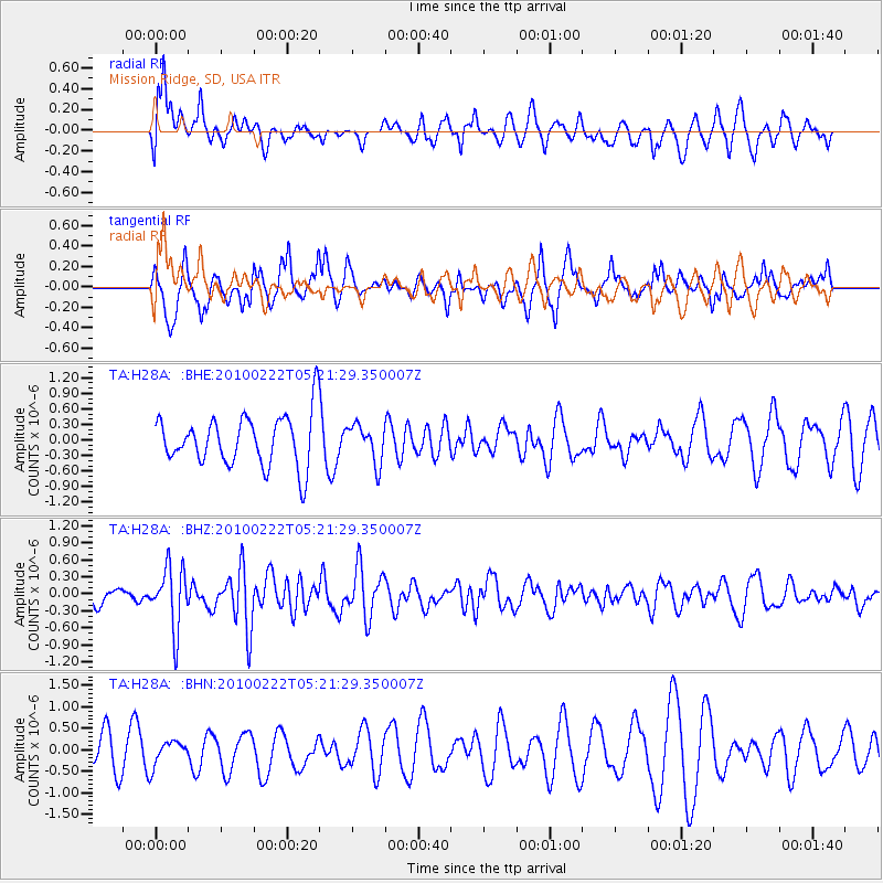
H28A Mission Ridge, SD, USA - Earthquake Result Viewer
*The percent match for this event was below the threshold and hence no stack was calculated.
| Earthquake location: |
Tonga Islands |
| Earthquake latitude/longitude: |
-21.5/-173.8 |
| Earthquake time(UTC): |
2010/02/22 (053) 05:08:49 GMT |
| Earthquake Depth: |
33 km |
| Earthquake Magnitude: |
5.8 MB, 5.3 MS, 5.7 MW, 5.7 MW |
| Earthquake Catalog/Contributor: |
WHDF/NEIC |
|
| Network: |
TA USArray Transportable Network (new EarthScope stations) |
| Station: |
H28A Mission Ridge, SD, USA |
| Lat/Lon: |
44.68 N/101.02 W |
| Elevation: |
642 m |
|
| Distance: |
93.4 deg |
| Az: |
43.045 deg |
| Baz: |
242.982 deg |
| Ray Param: |
$rayparam |
*The percent match for this event was below the threshold and hence was not used in the summary stack. |
|
| Radial Match: |
61.09972 % |
| Radial Bump: |
400 |
| Transverse Match: |
42.74576 % |
| Transverse Bump: |
337 |
| SOD ConfigId: |
307546 |
| Insert Time: |
2010-05-14 06:56:25.139 +0000 |
| GWidth: |
2.5 |
| Max Bumps: |
400 |
| Tol: |
0.001 |
|
Signal To Noise
| Channel | StoN | STA | LTA |
| TA:H28A: :BHZ:20100222T05:21:29.350007Z | 2.8237479 | 5.37781E-7 | 1.9044937E-7 |
| TA:H28A: :BHN:20100222T05:21:29.350007Z | 0.4362389 | 2.924442E-7 | 6.7037627E-7 |
| TA:H28A: :BHE:20100222T05:21:29.350007Z | 0.74378234 | 3.652474E-7 | 4.9106757E-7 |
| Arrivals |
| Ps | |
| PpPs | |
| PsPs/PpSs | |


