You are here: Home > Network List > TA - USArray Transportable Network (new EarthScope stations) Stations List
> Station F29A Eureka, SD, USA > Earthquake Result Viewer
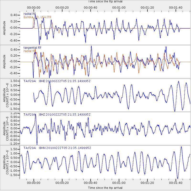
F29A Eureka, SD, USA - Earthquake Result Viewer
*The percent match for this event was below the threshold and hence no stack was calculated.
| Earthquake location: |
Tonga Islands |
| Earthquake latitude/longitude: |
-21.5/-173.8 |
| Earthquake time(UTC): |
2010/02/22 (053) 05:08:49 GMT |
| Earthquake Depth: |
33 km |
| Earthquake Magnitude: |
5.8 MB, 5.3 MS, 5.7 MW, 5.7 MW |
| Earthquake Catalog/Contributor: |
WHDF/NEIC |
|
| Network: |
TA USArray Transportable Network (new EarthScope stations) |
| Station: |
F29A Eureka, SD, USA |
| Lat/Lon: |
45.83 N/99.83 W |
| Elevation: |
575 m |
|
| Distance: |
94.6 deg |
| Az: |
42.384 deg |
| Baz: |
243.872 deg |
| Ray Param: |
$rayparam |
*The percent match for this event was below the threshold and hence was not used in the summary stack. |
|
| Radial Match: |
71.59977 % |
| Radial Bump: |
400 |
| Transverse Match: |
48.44574 % |
| Transverse Bump: |
338 |
| SOD ConfigId: |
307546 |
| Insert Time: |
2010-05-14 06:57:09.212 +0000 |
| GWidth: |
2.5 |
| Max Bumps: |
400 |
| Tol: |
0.001 |
|
Signal To Noise
| Channel | StoN | STA | LTA |
| TA:F29A: :BHZ:20100222T05:21:35.149995Z | 3.224798 | 5.51059E-7 | 1.7088172E-7 |
| TA:F29A: :BHN:20100222T05:21:35.149995Z | 0.3821213 | 2.621438E-7 | 6.860224E-7 |
| TA:F29A: :BHE:20100222T05:21:35.149995Z | 1.1458166 | 6.718313E-7 | 5.8633407E-7 |
| Arrivals |
| Ps | |
| PpPs | |
| PsPs/PpSs | |


