You are here: Home > Network List > TA - USArray Transportable Network (new EarthScope stations) Stations List
> Station J04D Umpqua National Forest, Toketee, OR, USA > Earthquake Result Viewer
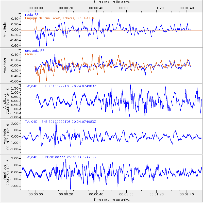
J04D Umpqua National Forest, Toketee, OR, USA - Earthquake Result Viewer
*The percent match for this event was below the threshold and hence no stack was calculated.
| Earthquake location: |
Tonga Islands |
| Earthquake latitude/longitude: |
-21.5/-173.8 |
| Earthquake time(UTC): |
2010/02/22 (053) 05:08:49 GMT |
| Earthquake Depth: |
33 km |
| Earthquake Magnitude: |
5.8 MB, 5.3 MS, 5.7 MW, 5.7 MW |
| Earthquake Catalog/Contributor: |
WHDF/NEIC |
|
| Network: |
TA USArray Transportable Network (new EarthScope stations) |
| Station: |
J04D Umpqua National Forest, Toketee, OR, USA |
| Lat/Lon: |
43.24 N/122.11 W |
| Elevation: |
1948 m |
|
| Distance: |
80.0 deg |
| Az: |
35.594 deg |
| Baz: |
227.873 deg |
| Ray Param: |
$rayparam |
*The percent match for this event was below the threshold and hence was not used in the summary stack. |
|
| Radial Match: |
62.263443 % |
| Radial Bump: |
400 |
| Transverse Match: |
54.23526 % |
| Transverse Bump: |
400 |
| SOD ConfigId: |
307546 |
| Insert Time: |
2010-05-14 06:57:39.298 +0000 |
| GWidth: |
2.5 |
| Max Bumps: |
400 |
| Tol: |
0.001 |
|
Signal To Noise
| Channel | StoN | STA | LTA |
| TA:J04D: :BHZ:20100222T05:20:24.074983Z | 3.946095 | 8.3253855E-7 | 2.1097783E-7 |
| TA:J04D: :BHN:20100222T05:20:24.074983Z | 1.3023742 | 4.9220995E-7 | 3.779328E-7 |
| TA:J04D: :BHE:20100222T05:20:24.074983Z | 1.4795518 | 6.0807673E-7 | 4.1098713E-7 |
| Arrivals |
| Ps | |
| PpPs | |
| PsPs/PpSs | |


