You are here: Home > Network List > TA - USArray Transportable Network (new EarthScope stations) Stations List
> Station 534A Blanco, TX, USA > Earthquake Result Viewer
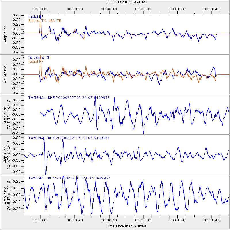
534A Blanco, TX, USA - Earthquake Result Viewer
*The percent match for this event was below the threshold and hence no stack was calculated.
| Earthquake location: |
Tonga Islands |
| Earthquake latitude/longitude: |
-21.5/-173.8 |
| Earthquake time(UTC): |
2010/02/22 (053) 05:08:49 GMT |
| Earthquake Depth: |
33 km |
| Earthquake Magnitude: |
5.8 MB, 5.3 MS, 5.7 MW, 5.7 MW |
| Earthquake Catalog/Contributor: |
WHDF/NEIC |
|
| Network: |
TA USArray Transportable Network (new EarthScope stations) |
| Station: |
534A Blanco, TX, USA |
| Lat/Lon: |
30.03 N/98.48 W |
| Elevation: |
461 m |
|
| Distance: |
88.7 deg |
| Az: |
57.043 deg |
| Baz: |
244.285 deg |
| Ray Param: |
$rayparam |
*The percent match for this event was below the threshold and hence was not used in the summary stack. |
|
| Radial Match: |
68.71397 % |
| Radial Bump: |
400 |
| Transverse Match: |
53.165905 % |
| Transverse Bump: |
400 |
| SOD ConfigId: |
307546 |
| Insert Time: |
2010-05-14 06:58:42.264 +0000 |
| GWidth: |
2.5 |
| Max Bumps: |
400 |
| Tol: |
0.001 |
|
Signal To Noise
| Channel | StoN | STA | LTA |
| TA:534A: :BHZ:20100222T05:21:07.649995Z | 3.29376 | 4.7832555E-7 | 1.4522173E-7 |
| TA:534A: :BHN:20100222T05:21:07.649995Z | 0.9936169 | 1.17521815E-7 | 1.18276795E-7 |
| TA:534A: :BHE:20100222T05:21:07.649995Z | 2.0042036 | 2.0012203E-7 | 9.985115E-8 |
| Arrivals |
| Ps | |
| PpPs | |
| PsPs/PpSs | |


