You are here: Home > Network List > AV - Alaska Volcano Observatory Stations List
> Station MNAT Nateekin Bay, Makushin Volcano, Alaska > Earthquake Result Viewer
MNAT Nateekin Bay, Makushin Volcano, Alaska - Earthquake Result Viewer
| Earthquake location: |
New Guinea, Papua New Guinea |
| Earthquake latitude/longitude: |
-4.3/143.2 |
| Earthquake time(UTC): |
2023/04/02 (092) 18:04:12 GMT |
| Earthquake Depth: |
74 km |
| Earthquake Magnitude: |
7.3 Mi |
| Earthquake Catalog/Contributor: |
NEIC PDE/pt |
|
| Network: |
AV Alaska Volcano Observatory |
| Station: |
MNAT Nateekin Bay, Makushin Volcano, Alaska |
| Lat/Lon: |
53.88 N/166.69 W |
| Elevation: |
390 m |
|
| Distance: |
71.5 deg |
| Az: |
28.63 deg |
| Baz: |
233.81 deg |
| Ray Param: |
0.054155298 |
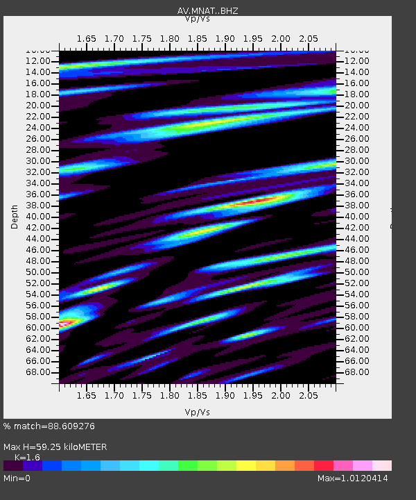
| Estimated Moho Depth: |
59.25 km |
| Estimated Crust Vp/Vs: |
1.60 |
| Assumed Crust Vp: |
3.943 km/s |
| Estimated Crust Vs: |
2.465 km/s |
| Estimated Crust Poisson's Ratio: |
0.18 |
|
| Radial Match: |
88.609276 % |
| Radial Bump: |
400 |
| Transverse Match: |
76.26484 % |
| Transverse Bump: |
400 |
| SOD ConfigId: |
30536071 |
| Insert Time: |
2023-04-16 18:12:55.716 +0000 |
| GWidth: |
2.5 |
| Max Bumps: |
400 |
| Tol: |
0.001 |
|

Signal To Noise
| Channel | StoN | STA | LTA |
| AV:MNAT: :BHZ:20230402T18:14:53.700012Z | 13.606656 | 7.6282413E-6 | 5.606257E-7 |
| AV:MNAT: :BHN:20230402T18:14:53.700012Z | 3.5567641 | 1.8466824E-6 | 5.1920296E-7 |
| AV:MNAT: :BHE:20230402T18:14:53.700012Z | 4.687293 | 2.6785917E-6 | 5.7145814E-7 |
| Arrivals |
| Ps | 9.1 SECOND |
| PpPs | 39 SECOND |
| PsPs/PpSs | 48 SECOND |


