You are here: Home > Network List > AV - Alaska Volcano Observatory Stations List
> Station R17L Mt. Peulik Volcano, AVO PLK4, AK, USA > Earthquake Result Viewer
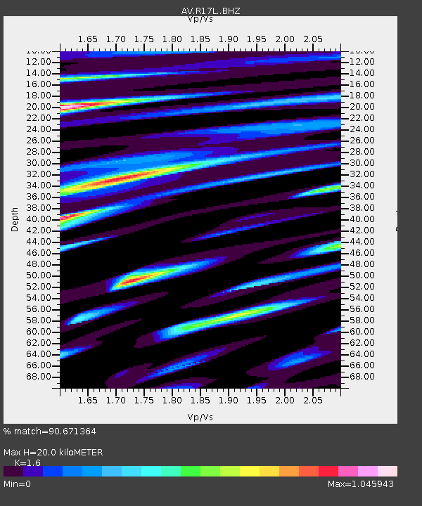
R17L Mt. Peulik Volcano, AVO PLK4, AK, USA - Earthquake Result Viewer
| Earthquake location: |
New Guinea, Papua New Guinea |
| Earthquake latitude/longitude: |
-4.3/143.2 |
| Earthquake time(UTC): |
2023/04/02 (092) 18:04:12 GMT |
| Earthquake Depth: |
74 km |
| Earthquake Magnitude: |
7.3 Mi |
| Earthquake Catalog/Contributor: |
NEIC PDE/pt |
|
| Network: |
AV Alaska Volcano Observatory |
| Station: |
R17L Mt. Peulik Volcano, AVO PLK4, AK, USA |
| Lat/Lon: |
57.63 N/156.36 W |
| Elevation: |
524 m |
|
| Distance: |
78.4 deg |
| Az: |
28.535 deg |
| Baz: |
242.315 deg |
| Ray Param: |
0.049520303 |
| Estimated Moho Depth: |
20.0 km |
| Estimated Crust Vp/Vs: |
1.60 |
| Assumed Crust Vp: |
6.1 km/s |
| Estimated Crust Vs: |
3.812 km/s |
| Estimated Crust Poisson's Ratio: |
0.18 |
|
| Radial Match: |
90.671364 % |
| Radial Bump: |
400 |
| Transverse Match: |
84.4035 % |
| Transverse Bump: |
400 |
| SOD ConfigId: |
30536071 |
| Insert Time: |
2023-04-16 18:13:33.996 +0000 |
| GWidth: |
2.5 |
| Max Bumps: |
400 |
| Tol: |
0.001 |
|

Signal To Noise
| Channel | StoN | STA | LTA |
| AV:R17L: :BHZ:20230402T18:15:33.525024Z | 27.51122 | 7.788046E-6 | 2.830862E-7 |
| AV:R17L: :BHN:20230402T18:15:33.525024Z | 3.7365322 | 9.417901E-7 | 2.5204923E-7 |
| AV:R17L: :BHE:20230402T18:15:33.525024Z | 10.726024 | 2.6292817E-6 | 2.4513108E-7 |
| Arrivals |
| Ps | 2.0 SECOND |
| PpPs | 8.3 SECOND |
| PsPs/PpSs | 10 SECOND |


