You are here: Home > Network List > AV - Alaska Volcano Observatory Stations List
> Station SPU Mount Spurr, Mount Spurr, Alaska > Earthquake Result Viewer
SPU Mount Spurr, Mount Spurr, Alaska - Earthquake Result Viewer
| Earthquake location: |
New Guinea, Papua New Guinea |
| Earthquake latitude/longitude: |
-4.3/143.2 |
| Earthquake time(UTC): |
2023/04/02 (092) 18:04:12 GMT |
| Earthquake Depth: |
74 km |
| Earthquake Magnitude: |
7.3 Mi |
| Earthquake Catalog/Contributor: |
NEIC PDE/pt |
|
| Network: |
AV Alaska Volcano Observatory |
| Station: |
SPU Mount Spurr, Mount Spurr, Alaska |
| Lat/Lon: |
61.18 N/152.06 W |
| Elevation: |
800 m |
|
| Distance: |
81.9 deg |
| Az: |
26.27 deg |
| Baz: |
245.627 deg |
| Ray Param: |
0.047093146 |
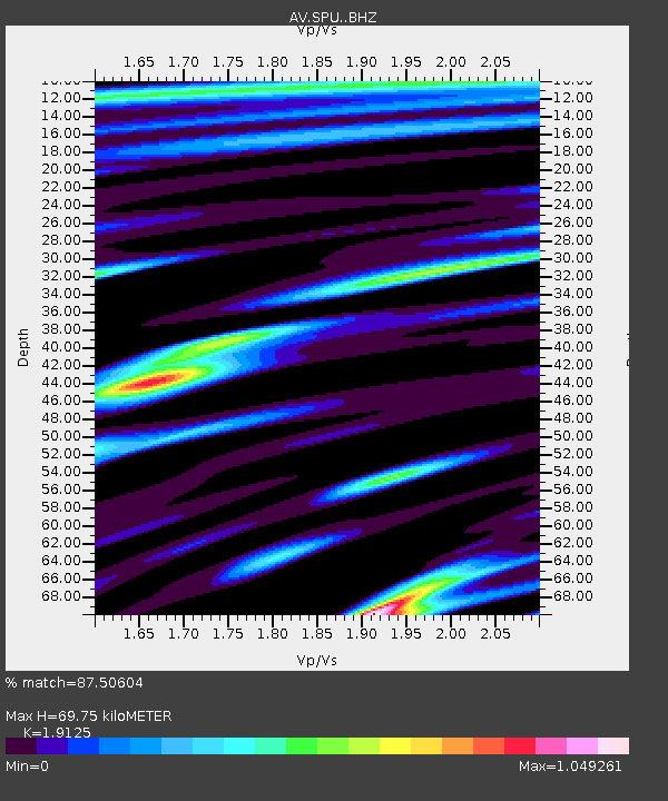
| Estimated Moho Depth: |
69.75 km |
| Estimated Crust Vp/Vs: |
1.91 |
| Assumed Crust Vp: |
6.566 km/s |
| Estimated Crust Vs: |
3.433 km/s |
| Estimated Crust Poisson's Ratio: |
0.31 |
|
| Radial Match: |
87.50604 % |
| Radial Bump: |
400 |
| Transverse Match: |
83.48912 % |
| Transverse Bump: |
400 |
| SOD ConfigId: |
30536071 |
| Insert Time: |
2023-04-16 18:13:56.615 +0000 |
| GWidth: |
2.5 |
| Max Bumps: |
400 |
| Tol: |
0.001 |
|
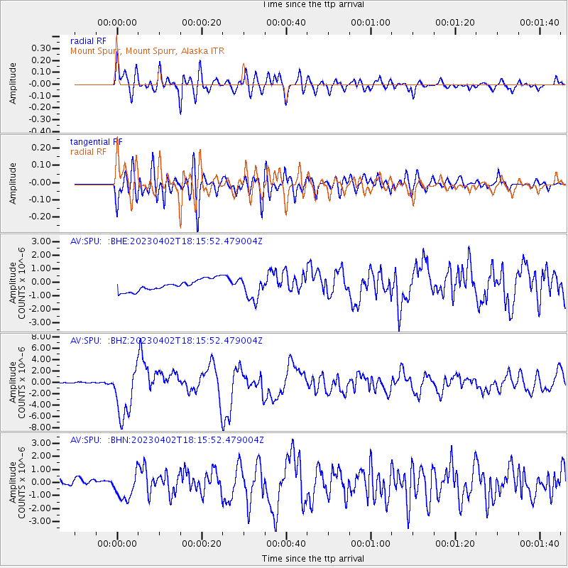
Signal To Noise
| Channel | StoN | STA | LTA |
| AV:SPU: :BHZ:20230402T18:15:52.479004Z | 36.917458 | 4.63839E-6 | 1.2564217E-7 |
| AV:SPU: :BHN:20230402T18:15:52.479004Z | 4.6161194 | 1.0485735E-6 | 2.2715477E-7 |
| AV:SPU: :BHE:20230402T18:15:52.479004Z | 1.9608701 | 8.3270476E-7 | 4.2466084E-7 |
| Arrivals |
| Ps | 9.9 SECOND |
| PpPs | 30 SECOND |
| PsPs/PpSs | 40 SECOND |


