You are here: Home > Network List > CN - Canadian National Seismograph Network Stations List
> Station PABB Port Alberni, BC, CA > Earthquake Result Viewer
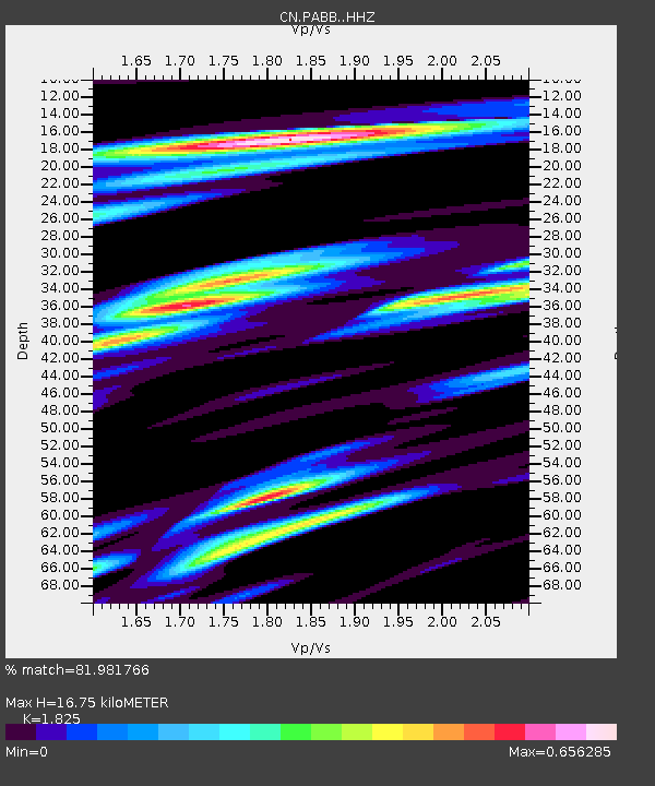
PABB Port Alberni, BC, CA - Earthquake Result Viewer
| Earthquake location: |
New Guinea, Papua New Guinea |
| Earthquake latitude/longitude: |
-4.3/143.2 |
| Earthquake time(UTC): |
2023/04/02 (092) 18:04:12 GMT |
| Earthquake Depth: |
74 km |
| Earthquake Magnitude: |
7.3 Mi |
| Earthquake Catalog/Contributor: |
NEIC PDE/pt |
|
| Network: |
CN Canadian National Seismograph Network |
| Station: |
PABB Port Alberni, BC, CA |
| Lat/Lon: |
49.22 N/124.81 W |
| Elevation: |
3.0 m |
|
| Distance: |
94.6 deg |
| Az: |
41.099 deg |
| Baz: |
268.67 deg |
| Ray Param: |
0.040970962 |
| Estimated Moho Depth: |
16.75 km |
| Estimated Crust Vp/Vs: |
1.83 |
| Assumed Crust Vp: |
6.391 km/s |
| Estimated Crust Vs: |
3.502 km/s |
| Estimated Crust Poisson's Ratio: |
0.29 |
|
| Radial Match: |
81.981766 % |
| Radial Bump: |
400 |
| Transverse Match: |
55.631283 % |
| Transverse Bump: |
372 |
| SOD ConfigId: |
30536071 |
| Insert Time: |
2023-04-16 18:17:35.472 +0000 |
| GWidth: |
2.5 |
| Max Bumps: |
400 |
| Tol: |
0.001 |
|

Signal To Noise
| Channel | StoN | STA | LTA |
| CN:PABB: :HHZ:20230402T18:16:53.039978Z | 2.6637483 | 1.4776003E-6 | 5.547072E-7 |
| CN:PABB: :HHN:20230402T18:16:53.039978Z | 0.83533794 | 2.699612E-7 | 3.2317604E-7 |
| CN:PABB: :HHE:20230402T18:16:53.039978Z | 2.0878353 | 5.547846E-7 | 2.657224E-7 |
| Arrivals |
| Ps | 2.2 SECOND |
| PpPs | 7.3 SECOND |
| PsPs/PpSs | 9.5 SECOND |


