You are here: Home > Network List > G - GEOSCOPE Stations List
> Station ROCAM Leguat Reserve, Rodrigues Island, Republic of Mauritius > Earthquake Result Viewer
ROCAM Leguat Reserve, Rodrigues Island, Republic of Mauritius - Earthquake Result Viewer
| Earthquake location: |
New Guinea, Papua New Guinea |
| Earthquake latitude/longitude: |
-4.3/143.2 |
| Earthquake time(UTC): |
2023/04/02 (092) 18:04:12 GMT |
| Earthquake Depth: |
74 km |
| Earthquake Magnitude: |
7.3 Mi |
| Earthquake Catalog/Contributor: |
NEIC PDE/pt |
|
| Network: |
G GEOSCOPE |
| Station: |
ROCAM Leguat Reserve, Rodrigues Island, Republic of Mauritius |
| Lat/Lon: |
19.76 S/63.37 E |
| Elevation: |
52 m |
|
| Distance: |
79.0 deg |
| Az: |
250.816 deg |
| Baz: |
90.679 deg |
| Ray Param: |
0.049124423 |
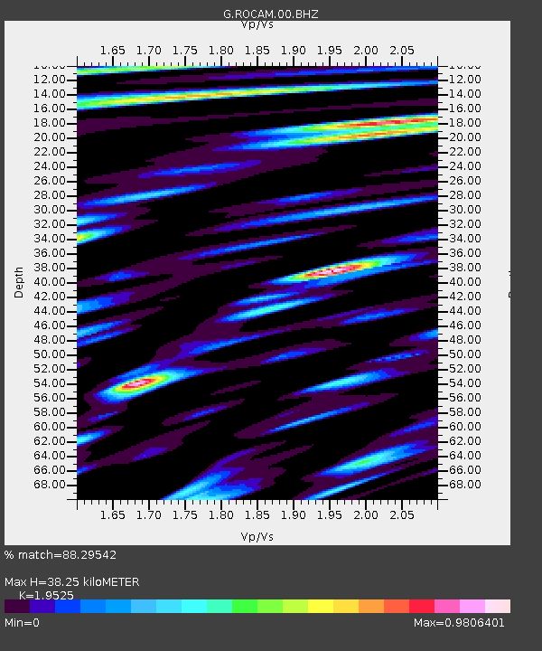
| Estimated Moho Depth: |
38.25 km |
| Estimated Crust Vp/Vs: |
1.95 |
| Assumed Crust Vp: |
4.802 km/s |
| Estimated Crust Vs: |
2.459 km/s |
| Estimated Crust Poisson's Ratio: |
0.32 |
|
| Radial Match: |
88.29542 % |
| Radial Bump: |
400 |
| Transverse Match: |
88.92151 % |
| Transverse Bump: |
400 |
| SOD ConfigId: |
30536071 |
| Insert Time: |
2023-04-16 18:18:27.706 +0000 |
| GWidth: |
2.5 |
| Max Bumps: |
400 |
| Tol: |
0.001 |
|

Signal To Noise
| Channel | StoN | STA | LTA |
| G:ROCAM:00:BHZ:20230402T18:15:36.750Z | 4.0622864 | 3.383629E-6 | 8.329371E-7 |
| G:ROCAM:00:BHN:20230402T18:15:36.750Z | 1.5265177 | 1.0295561E-6 | 6.7444756E-7 |
| G:ROCAM:00:BHE:20230402T18:15:36.750Z | 2.2810001 | 1.8266801E-6 | 8.0082424E-7 |
| Arrivals |
| Ps | 7.7 SECOND |
| PpPs | 23 SECOND |
| PsPs/PpSs | 31 SECOND |


