You are here: Home > Network List > US - United States National Seismic Network Stations List
> Station HAWA Hanford, Washington, USA > Earthquake Result Viewer
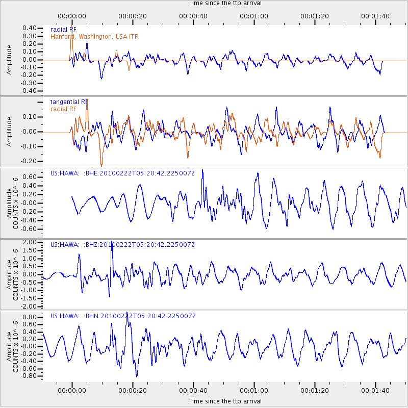
HAWA Hanford, Washington, USA - Earthquake Result Viewer
*The percent match for this event was below the threshold and hence no stack was calculated.
| Earthquake location: |
Tonga Islands |
| Earthquake latitude/longitude: |
-21.5/-173.8 |
| Earthquake time(UTC): |
2010/02/22 (053) 05:08:49 GMT |
| Earthquake Depth: |
33 km |
| Earthquake Magnitude: |
5.8 MB, 5.3 MS, 5.7 MW, 5.7 MW |
| Earthquake Catalog/Contributor: |
WHDF/NEIC |
|
| Network: |
US United States National Seismic Network |
| Station: |
HAWA Hanford, Washington, USA |
| Lat/Lon: |
46.39 N/119.53 W |
| Elevation: |
364 m |
|
| Distance: |
83.5 deg |
| Az: |
34.426 deg |
| Baz: |
229.516 deg |
| Ray Param: |
$rayparam |
*The percent match for this event was below the threshold and hence was not used in the summary stack. |
|
| Radial Match: |
51.12671 % |
| Radial Bump: |
400 |
| Transverse Match: |
44.103268 % |
| Transverse Bump: |
391 |
| SOD ConfigId: |
307546 |
| Insert Time: |
2010-05-14 07:03:11.774 +0000 |
| GWidth: |
2.5 |
| Max Bumps: |
400 |
| Tol: |
0.001 |
|
Signal To Noise
| Channel | StoN | STA | LTA |
| US:HAWA: :BHZ:20100222T05:20:42.225007Z | 2.361521 | 5.523788E-7 | 2.339081E-7 |
| US:HAWA: :BHN:20100222T05:20:42.225007Z | 1.5221032 | 3.1312206E-7 | 2.057167E-7 |
| US:HAWA: :BHE:20100222T05:20:42.225007Z | 0.83275473 | 1.540446E-7 | 1.8498197E-7 |
| Arrivals |
| Ps | |
| PpPs | |
| PsPs/PpSs | |


