You are here: Home > Network List > IW - Intermountain West Stations List
> Station PLID Pearl Lake, Idaho, USA > Earthquake Result Viewer
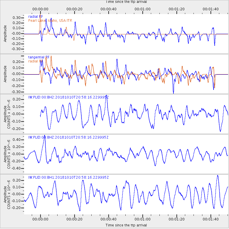
PLID Pearl Lake, Idaho, USA - Earthquake Result Viewer
*The percent match for this event was below the threshold and hence no stack was calculated.
| Earthquake location: |
New Britain Region, P.N.G. |
| Earthquake latitude/longitude: |
-5.8/151.3 |
| Earthquake time(UTC): |
2018/10/10 (283) 20:45:26 GMT |
| Earthquake Depth: |
52 km |
| Earthquake Magnitude: |
5.9 mb |
| Earthquake Catalog/Contributor: |
NEIC PDE/us |
|
| Network: |
IW Intermountain West |
| Station: |
PLID Pearl Lake, Idaho, USA |
| Lat/Lon: |
45.09 N/116.00 W |
| Elevation: |
2164 m |
|
| Distance: |
95.9 deg |
| Az: |
45.352 deg |
| Baz: |
267.806 deg |
| Ray Param: |
$rayparam |
*The percent match for this event was below the threshold and hence was not used in the summary stack. |
|
| Radial Match: |
66.44864 % |
| Radial Bump: |
400 |
| Transverse Match: |
54.33545 % |
| Transverse Bump: |
400 |
| SOD ConfigId: |
3045211 |
| Insert Time: |
2018-10-24 21:00:36.674 +0000 |
| GWidth: |
2.5 |
| Max Bumps: |
400 |
| Tol: |
0.001 |
|
Signal To Noise
| Channel | StoN | STA | LTA |
| IW:PLID:00:BHZ:20181010T20:58:16.229995Z | 3.1820226 | 2.6804517E-7 | 8.423735E-8 |
| IW:PLID:00:BH1:20181010T20:58:16.229995Z | 0.7543854 | 6.81492E-8 | 9.033737E-8 |
| IW:PLID:00:BH2:20181010T20:58:16.229995Z | 0.95807904 | 8.8953506E-8 | 9.284568E-8 |
| Arrivals |
| Ps | |
| PpPs | |
| PsPs/PpSs | |


