You are here: Home > Network List > MM - Myanmar National Seismic Network Stations List
> Station NGU Ngaung U, Myanmar > Earthquake Result Viewer
NGU Ngaung U, Myanmar - Earthquake Result Viewer
| Earthquake location: |
New Guinea, Papua New Guinea |
| Earthquake latitude/longitude: |
-4.3/143.2 |
| Earthquake time(UTC): |
2023/04/02 (092) 18:04:12 GMT |
| Earthquake Depth: |
74 km |
| Earthquake Magnitude: |
7.3 Mi |
| Earthquake Catalog/Contributor: |
NEIC PDE/pt |
|
| Network: |
MM Myanmar National Seismic Network |
| Station: |
NGU Ngaung U, Myanmar |
| Lat/Lon: |
21.21 N/94.92 E |
| Elevation: |
70 m |
|
| Distance: |
53.7 deg |
| Az: |
300.194 deg |
| Baz: |
112.531 deg |
| Ray Param: |
0.06571479 |
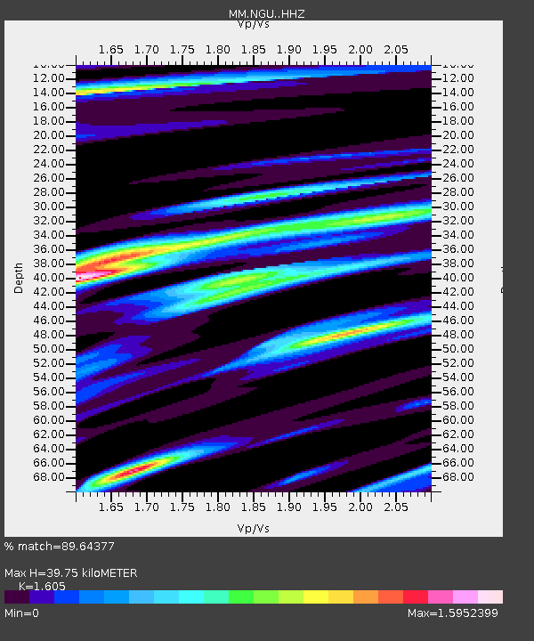
| Estimated Moho Depth: |
39.75 km |
| Estimated Crust Vp/Vs: |
1.61 |
| Assumed Crust Vp: |
6.036 km/s |
| Estimated Crust Vs: |
3.761 km/s |
| Estimated Crust Poisson's Ratio: |
0.18 |
|
| Radial Match: |
89.64377 % |
| Radial Bump: |
400 |
| Transverse Match: |
82.52287 % |
| Transverse Bump: |
388 |
| SOD ConfigId: |
30536071 |
| Insert Time: |
2023-04-16 18:21:02.304 +0000 |
| GWidth: |
2.5 |
| Max Bumps: |
400 |
| Tol: |
0.001 |
|

Signal To Noise
| Channel | StoN | STA | LTA |
| MM:NGU: :HHZ:20230402T18:12:55.650024Z | 58.360733 | 6.682954E-6 | 1.1451114E-7 |
| MM:NGU: :HHN:20230402T18:12:55.650024Z | 18.376188 | 1.2546114E-6 | 6.8273756E-8 |
| MM:NGU: :HHE:20230402T18:12:55.650024Z | 18.026714 | 2.06191E-6 | 1.14380796E-7 |
| Arrivals |
| Ps | 4.2 SECOND |
| PpPs | 16 SECOND |
| PsPs/PpSs | 20 SECOND |


