You are here: Home > Network List > PS - Pacific21 Stations List
> Station INU Inuyama, Japan > Earthquake Result Viewer
INU Inuyama, Japan - Earthquake Result Viewer
| Earthquake location: |
New Guinea, Papua New Guinea |
| Earthquake latitude/longitude: |
-4.3/143.2 |
| Earthquake time(UTC): |
2023/04/02 (092) 18:04:12 GMT |
| Earthquake Depth: |
74 km |
| Earthquake Magnitude: |
7.3 Mi |
| Earthquake Catalog/Contributor: |
NEIC PDE/pt |
|
| Network: |
PS Pacific21 |
| Station: |
INU Inuyama, Japan |
| Lat/Lon: |
35.35 N/137.03 E |
| Elevation: |
132 m |
|
| Distance: |
39.9 deg |
| Az: |
352.128 deg |
| Baz: |
170.383 deg |
| Ray Param: |
0.07448839 |
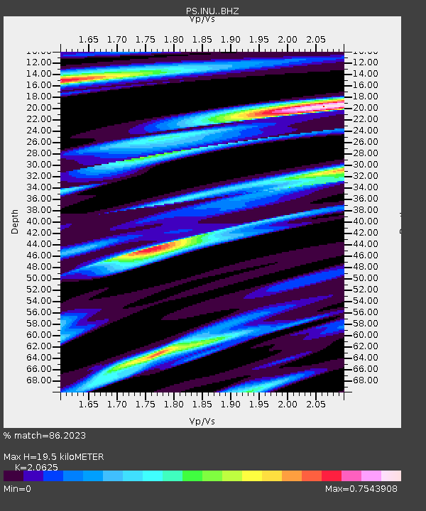
| Estimated Moho Depth: |
19.5 km |
| Estimated Crust Vp/Vs: |
2.06 |
| Assumed Crust Vp: |
6.461 km/s |
| Estimated Crust Vs: |
3.133 km/s |
| Estimated Crust Poisson's Ratio: |
0.35 |
|
| Radial Match: |
86.2023 % |
| Radial Bump: |
323 |
| Transverse Match: |
75.995255 % |
| Transverse Bump: |
400 |
| SOD ConfigId: |
30536071 |
| Insert Time: |
2023-04-16 18:22:13.378 +0000 |
| GWidth: |
2.5 |
| Max Bumps: |
400 |
| Tol: |
0.001 |
|

Signal To Noise
| Channel | StoN | STA | LTA |
| PS:INU: :BHZ:20230402T18:11:08.311005Z | 46.10975 | 1.7997041E-5 | 3.9030883E-7 |
| PS:INU: :BHN:20230402T18:11:08.311005Z | 22.508083 | 9.872093E-6 | 4.3860211E-7 |
| PS:INU: :BHE:20230402T18:11:08.311005Z | 6.34738 | 1.1570223E-6 | 1.8228344E-7 |
| Arrivals |
| Ps | 3.4 SECOND |
| PpPs | 8.7 SECOND |
| PsPs/PpSs | 12 SECOND |


