You are here: Home > Network List > UW - Pacific Northwest Regional Seismic Network Stations List
> Station LEBA Lebam, WA, USA > Earthquake Result Viewer
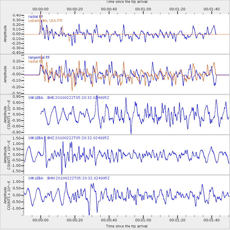
LEBA Lebam, WA, USA - Earthquake Result Viewer
*The percent match for this event was below the threshold and hence no stack was calculated.
| Earthquake location: |
Tonga Islands |
| Earthquake latitude/longitude: |
-21.5/-173.8 |
| Earthquake time(UTC): |
2010/02/22 (053) 05:08:49 GMT |
| Earthquake Depth: |
33 km |
| Earthquake Magnitude: |
5.8 MB, 5.3 MS, 5.7 MW, 5.7 MW |
| Earthquake Catalog/Contributor: |
WHDF/NEIC |
|
| Network: |
UW Pacific Northwest Regional Seismic Network |
| Station: |
LEBA Lebam, WA, USA |
| Lat/Lon: |
46.55 N/123.56 W |
| Elevation: |
73 m |
|
| Distance: |
81.5 deg |
| Az: |
32.429 deg |
| Baz: |
226.342 deg |
| Ray Param: |
$rayparam |
*The percent match for this event was below the threshold and hence was not used in the summary stack. |
|
| Radial Match: |
57.61636 % |
| Radial Bump: |
400 |
| Transverse Match: |
53.108788 % |
| Transverse Bump: |
400 |
| SOD ConfigId: |
307546 |
| Insert Time: |
2010-05-14 07:05:12.005 +0000 |
| GWidth: |
2.5 |
| Max Bumps: |
400 |
| Tol: |
0.001 |
|
Signal To Noise
| Channel | StoN | STA | LTA |
| UW:LEBA: :BHZ:20100222T05:20:32.024995Z | 2.041907 | 7.0388177E-7 | 3.4471782E-7 |
| UW:LEBA: :BHN:20100222T05:20:32.024995Z | 1.0810734 | 2.7159166E-7 | 2.5122407E-7 |
| UW:LEBA: :BHE:20100222T05:20:32.024995Z | 1.7292852 | 4.334704E-7 | 2.506645E-7 |
| Arrivals |
| Ps | |
| PpPs | |
| PsPs/PpSs | |


