You are here: Home > Network List > S1 - Australian Seismometers in Schools Stations List
> Station AUMTS Mt Stromlo > Earthquake Result Viewer
AUMTS Mt Stromlo - Earthquake Result Viewer
| Earthquake location: |
New Guinea, Papua New Guinea |
| Earthquake latitude/longitude: |
-4.3/143.2 |
| Earthquake time(UTC): |
2023/04/02 (092) 18:04:12 GMT |
| Earthquake Depth: |
74 km |
| Earthquake Magnitude: |
7.3 Mi |
| Earthquake Catalog/Contributor: |
NEIC PDE/pt |
|
| Network: |
S1 Australian Seismometers in Schools |
| Station: |
AUMTS Mt Stromlo |
| Lat/Lon: |
35.32 S/149.00 E |
| Elevation: |
667 m |
|
| Distance: |
31.3 deg |
| Az: |
170.847 deg |
| Baz: |
348.815 deg |
| Ray Param: |
0.0789704 |
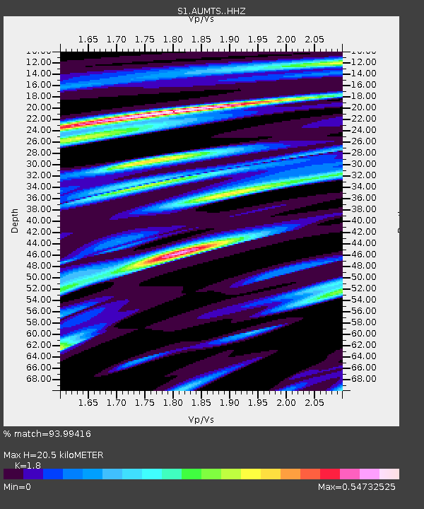
| Estimated Moho Depth: |
20.5 km |
| Estimated Crust Vp/Vs: |
1.80 |
| Assumed Crust Vp: |
6.633 km/s |
| Estimated Crust Vs: |
3.685 km/s |
| Estimated Crust Poisson's Ratio: |
0.28 |
|
| Radial Match: |
93.99416 % |
| Radial Bump: |
231 |
| Transverse Match: |
69.17752 % |
| Transverse Bump: |
400 |
| SOD ConfigId: |
30536071 |
| Insert Time: |
2023-04-16 18:23:17.259 +0000 |
| GWidth: |
2.5 |
| Max Bumps: |
400 |
| Tol: |
0.001 |
|

Signal To Noise
| Channel | StoN | STA | LTA |
| S1:AUMTS: :HHZ:20230402T18:09:54.790009Z | 6.2983103 | 2.9242435E-6 | 4.6429017E-7 |
| S1:AUMTS: :HHN:20230402T18:09:54.790009Z | 10.889211 | 2.0123975E-6 | 1.8480657E-7 |
| S1:AUMTS: :HHE:20230402T18:09:54.790009Z | 1.243128 | 4.998529E-7 | 4.020929E-7 |
| Arrivals |
| Ps | 2.7 SECOND |
| PpPs | 8.0 SECOND |
| PsPs/PpSs | 11 SECOND |


