You are here: Home > Network List > TA - USArray Transportable Network (new EarthScope stations) Stations List
> Station L02D Cave Junction, OR, USA > Earthquake Result Viewer
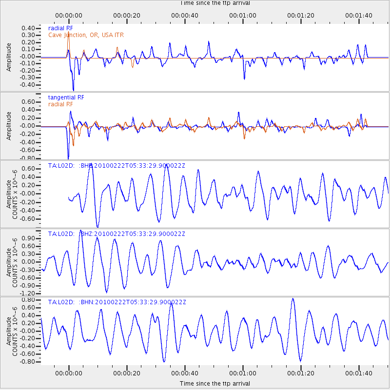
L02D Cave Junction, OR, USA - Earthquake Result Viewer
*The percent match for this event was below the threshold and hence no stack was calculated.
| Earthquake location: |
Taiwan Region |
| Earthquake latitude/longitude: |
24.1/122.9 |
| Earthquake time(UTC): |
2010/02/22 (053) 05:21:04 GMT |
| Earthquake Depth: |
29 km |
| Earthquake Magnitude: |
5.5 MB, 5.5 MW, 6.0 ML |
| Earthquake Catalog/Contributor: |
WHDF/NEIC |
|
| Network: |
TA USArray Transportable Network (new EarthScope stations) |
| Station: |
L02D Cave Junction, OR, USA |
| Lat/Lon: |
42.16 N/123.60 W |
| Elevation: |
458 m |
|
| Distance: |
89.9 deg |
| Az: |
43.006 deg |
| Baz: |
303.056 deg |
| Ray Param: |
$rayparam |
*The percent match for this event was below the threshold and hence was not used in the summary stack. |
|
| Radial Match: |
64.14998 % |
| Radial Bump: |
400 |
| Transverse Match: |
67.05025 % |
| Transverse Bump: |
400 |
| SOD ConfigId: |
307546 |
| Insert Time: |
2010-05-14 07:10:08.674 +0000 |
| GWidth: |
2.5 |
| Max Bumps: |
400 |
| Tol: |
0.001 |
|
Signal To Noise
| Channel | StoN | STA | LTA |
| TA:L02D: :BHZ:20100222T05:33:29.900022Z | 2.4898539 | 6.662477E-7 | 2.6758505E-7 |
| TA:L02D: :BHN:20100222T05:33:29.900022Z | 1.1162298 | 3.455621E-7 | 3.0957972E-7 |
| TA:L02D: :BHE:20100222T05:33:29.900022Z | 1.547241 | 4.7668655E-7 | 3.0808812E-7 |
| Arrivals |
| Ps | |
| PpPs | |
| PsPs/PpSs | |


