You are here: Home > Network List > US - United States National Seismic Network Stations List
> Station DGMT Dagmar, Montana, USA > Earthquake Result Viewer
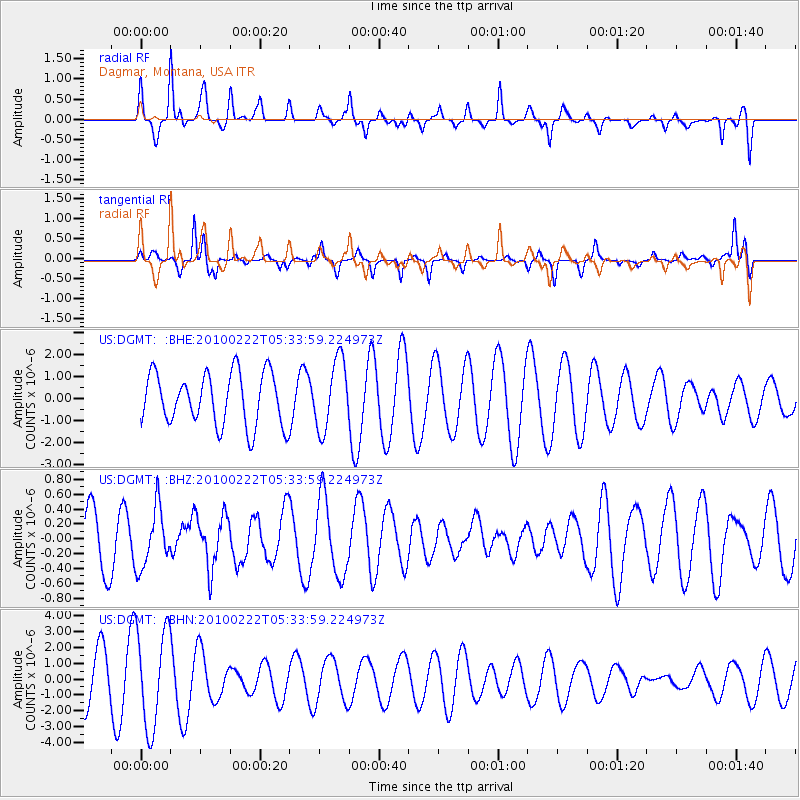
DGMT Dagmar, Montana, USA - Earthquake Result Viewer
*The percent match for this event was below the threshold and hence no stack was calculated.
| Earthquake location: |
Taiwan Region |
| Earthquake latitude/longitude: |
24.1/122.9 |
| Earthquake time(UTC): |
2010/02/22 (053) 05:21:04 GMT |
| Earthquake Depth: |
29 km |
| Earthquake Magnitude: |
5.5 MB, 5.5 MW, 6.0 ML |
| Earthquake Catalog/Contributor: |
WHDF/NEIC |
|
| Network: |
US United States National Seismic Network |
| Station: |
DGMT Dagmar, Montana, USA |
| Lat/Lon: |
48.47 N/104.20 W |
| Elevation: |
0.0 m |
|
| Distance: |
96.3 deg |
| Az: |
29.39 deg |
| Baz: |
317.643 deg |
| Ray Param: |
$rayparam |
*The percent match for this event was below the threshold and hence was not used in the summary stack. |
|
| Radial Match: |
64.12792 % |
| Radial Bump: |
275 |
| Transverse Match: |
53.382618 % |
| Transverse Bump: |
249 |
| SOD ConfigId: |
307546 |
| Insert Time: |
2010-05-14 07:10:16.085 +0000 |
| GWidth: |
2.5 |
| Max Bumps: |
400 |
| Tol: |
0.001 |
|
Signal To Noise
| Channel | StoN | STA | LTA |
| US:DGMT: :BHZ:20100222T05:33:59.224973Z | 0.9469146 | 3.9310672E-7 | 4.1514483E-7 |
| US:DGMT: :BHN:20100222T05:33:59.224973Z | 2.1803951 | 3.0964898E-6 | 1.4201507E-6 |
| US:DGMT: :BHE:20100222T05:33:59.224973Z | 1.331562 | 1.5772848E-6 | 1.1845373E-6 |
| Arrivals |
| Ps | |
| PpPs | |
| PsPs/PpSs | |


