You are here: Home > Network List > US - United States National Seismic Network Stations List
> Station HAWA Hanford, Washington, USA > Earthquake Result Viewer
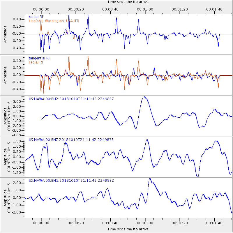
HAWA Hanford, Washington, USA - Earthquake Result Viewer
*The percent match for this event was below the threshold and hence no stack was calculated.
| Earthquake location: |
New Britain Region, P.N.G. |
| Earthquake latitude/longitude: |
-6.0/151.1 |
| Earthquake time(UTC): |
2018/10/10 (283) 20:59:01 GMT |
| Earthquake Depth: |
49 km |
| Earthquake Magnitude: |
5.7 mb |
| Earthquake Catalog/Contributor: |
NEIC PDE/us |
|
| Network: |
US United States National Seismic Network |
| Station: |
HAWA Hanford, Washington, USA |
| Lat/Lon: |
46.39 N/119.53 W |
| Elevation: |
364 m |
|
| Distance: |
93.9 deg |
| Az: |
43.922 deg |
| Baz: |
265.445 deg |
| Ray Param: |
$rayparam |
*The percent match for this event was below the threshold and hence was not used in the summary stack. |
|
| Radial Match: |
57.48402 % |
| Radial Bump: |
214 |
| Transverse Match: |
38.651974 % |
| Transverse Bump: |
307 |
| SOD ConfigId: |
3045211 |
| Insert Time: |
2018-10-24 21:04:10.361 +0000 |
| GWidth: |
2.5 |
| Max Bumps: |
400 |
| Tol: |
0.001 |
|
Signal To Noise
| Channel | StoN | STA | LTA |
| US:HAWA:00:BHZ:20181010T21:11:42.224983Z | 1.697435 | 8.295939E-7 | 4.887338E-7 |
| US:HAWA:00:BH1:20181010T21:11:42.224983Z | 0.8604235 | 1.7844502E-7 | 2.0739208E-7 |
| US:HAWA:00:BH2:20181010T21:11:42.224983Z | 1.8278751 | 6.0019255E-7 | 3.2835533E-7 |
| Arrivals |
| Ps | |
| PpPs | |
| PsPs/PpSs | |


