You are here: Home > Network List > CC - Cascade Chain Volcano Monitoring Stations List
> Station PANH Panhandle Gap > Earthquake Result Viewer
PANH Panhandle Gap - Earthquake Result Viewer
| Earthquake location: |
Near East Coast Of Kamchatka |
| Earthquake latitude/longitude: |
52.8/158.6 |
| Earthquake time(UTC): |
2023/04/03 (093) 03:06:55 GMT |
| Earthquake Depth: |
100 km |
| Earthquake Magnitude: |
6.7 Mi |
| Earthquake Catalog/Contributor: |
NEIC PDE/at |
|
| Network: |
CC Cascade Chain Volcano Monitoring |
| Station: |
PANH Panhandle Gap |
| Lat/Lon: |
46.86 N/121.64 W |
| Elevation: |
2086 m |
|
| Distance: |
49.3 deg |
| Az: |
62.959 deg |
| Baz: |
307.995 deg |
| Ray Param: |
0.06847921 |
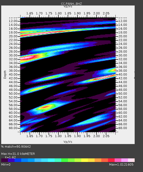
| Estimated Moho Depth: |
31.0 km |
| Estimated Crust Vp/Vs: |
1.62 |
| Assumed Crust Vp: |
6.597 km/s |
| Estimated Crust Vs: |
4.073 km/s |
| Estimated Crust Poisson's Ratio: |
0.19 |
|
| Radial Match: |
90.90642 % |
| Radial Bump: |
400 |
| Transverse Match: |
81.64957 % |
| Transverse Bump: |
400 |
| SOD ConfigId: |
30536071 |
| Insert Time: |
2023-04-17 03:14:47.263 +0000 |
| GWidth: |
2.5 |
| Max Bumps: |
400 |
| Tol: |
0.001 |
|

Signal To Noise
| Channel | StoN | STA | LTA |
| CC:PANH: :BHZ:20230403T03:15:03.339996Z | 2.924032 | 5.4064407E-7 | 1.8489676E-7 |
| CC:PANH: :BHN:20230403T03:15:03.339996Z | 1.6222175 | 2.5946352E-7 | 1.5994372E-7 |
| CC:PANH: :BHE:20230403T03:15:03.339996Z | 0.81173825 | 2.3305927E-7 | 2.8711136E-7 |
| Arrivals |
| Ps | 3.1 SECOND |
| PpPs | 12 SECOND |
| PsPs/PpSs | 15 SECOND |


