You are here: Home > Network List > CI - Caltech Regional Seismic Network Stations List
> Station BAR Barrett, Tecate, CA, USA > Earthquake Result Viewer
BAR Barrett, Tecate, CA, USA - Earthquake Result Viewer
| Earthquake location: |
Near East Coast Of Kamchatka |
| Earthquake latitude/longitude: |
52.8/158.6 |
| Earthquake time(UTC): |
2023/04/03 (093) 03:06:55 GMT |
| Earthquake Depth: |
100 km |
| Earthquake Magnitude: |
6.7 Mi |
| Earthquake Catalog/Contributor: |
NEIC PDE/at |
|
| Network: |
CI Caltech Regional Seismic Network |
| Station: |
BAR Barrett, Tecate, CA, USA |
| Lat/Lon: |
32.68 N/116.67 W |
| Elevation: |
521 m |
|
| Distance: |
61.7 deg |
| Az: |
72.504 deg |
| Baz: |
316.634 deg |
| Ray Param: |
0.0604351 |
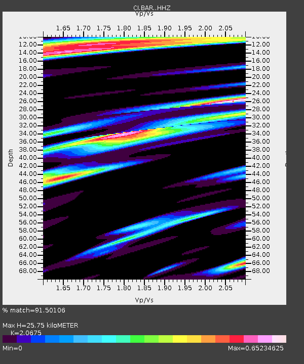
| Estimated Moho Depth: |
25.75 km |
| Estimated Crust Vp/Vs: |
2.07 |
| Assumed Crust Vp: |
6.264 km/s |
| Estimated Crust Vs: |
3.03 km/s |
| Estimated Crust Poisson's Ratio: |
0.35 |
|
| Radial Match: |
91.50106 % |
| Radial Bump: |
400 |
| Transverse Match: |
83.74033 % |
| Transverse Bump: |
400 |
| SOD ConfigId: |
30536071 |
| Insert Time: |
2023-04-17 03:15:43.503 +0000 |
| GWidth: |
2.5 |
| Max Bumps: |
400 |
| Tol: |
0.001 |
|

Signal To Noise
| Channel | StoN | STA | LTA |
| CI:BAR: :HHZ:20230403T03:16:31.91803Z | 3.8052588 | 7.206731E-7 | 1.8938871E-7 |
| CI:BAR: :HHN:20230403T03:16:31.91803Z | 1.6699276 | 2.3568477E-7 | 1.4113472E-7 |
| CI:BAR: :HHE:20230403T03:16:31.91803Z | 2.6291676 | 3.0163525E-7 | 1.14726525E-7 |
| Arrivals |
| Ps | 4.6 SECOND |
| PpPs | 12 SECOND |
| PsPs/PpSs | 17 SECOND |


