You are here: Home > Network List > TA - USArray Transportable Network (new EarthScope stations) Stations List
> Station 532A Rocksprings, TX, USA > Earthquake Result Viewer
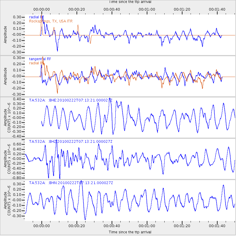
532A Rocksprings, TX, USA - Earthquake Result Viewer
*The percent match for this event was below the threshold and hence no stack was calculated.
| Earthquake location: |
South Of Fiji Islands |
| Earthquake latitude/longitude: |
-23.6/-176.0 |
| Earthquake time(UTC): |
2010/02/22 (053) 07:00:52 GMT |
| Earthquake Depth: |
25 km |
| Earthquake Magnitude: |
5.5 MB, 5.8 MS, 6.0 MW, 5.9 MW |
| Earthquake Catalog/Contributor: |
WHDF/NEIC |
|
| Network: |
TA USArray Transportable Network (new EarthScope stations) |
| Station: |
532A Rocksprings, TX, USA |
| Lat/Lon: |
30.13 N/99.90 W |
| Elevation: |
703 m |
|
| Distance: |
90.5 deg |
| Az: |
57.261 deg |
| Baz: |
242.924 deg |
| Ray Param: |
$rayparam |
*The percent match for this event was below the threshold and hence was not used in the summary stack. |
|
| Radial Match: |
51.944565 % |
| Radial Bump: |
400 |
| Transverse Match: |
53.60291 % |
| Transverse Bump: |
400 |
| SOD ConfigId: |
307546 |
| Insert Time: |
2010-05-14 07:21:12.232 +0000 |
| GWidth: |
2.5 |
| Max Bumps: |
400 |
| Tol: |
0.001 |
|
Signal To Noise
| Channel | StoN | STA | LTA |
| TA:532A: :BHZ:20100222T07:13:21.000027Z | 3.3151875 | 3.3546516E-7 | 1.0119041E-7 |
| TA:532A: :BHN:20100222T07:13:21.000027Z | 0.73397315 | 9.666312E-8 | 1.3169846E-7 |
| TA:532A: :BHE:20100222T07:13:21.000027Z | 1.5962822 | 2.3042979E-7 | 1.4435403E-7 |
| Arrivals |
| Ps | |
| PpPs | |
| PsPs/PpSs | |


