You are here: Home > Network List > TA - USArray Transportable Network (new EarthScope stations) Stations List
> Station 130A Snyder, TX, USA > Earthquake Result Viewer
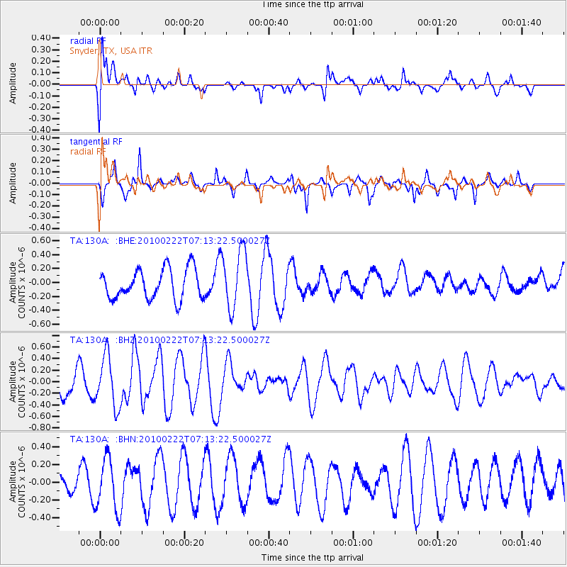
130A Snyder, TX, USA - Earthquake Result Viewer
*The percent match for this event was below the threshold and hence no stack was calculated.
| Earthquake location: |
South Of Fiji Islands |
| Earthquake latitude/longitude: |
-23.6/-176.0 |
| Earthquake time(UTC): |
2010/02/22 (053) 07:00:52 GMT |
| Earthquake Depth: |
25 km |
| Earthquake Magnitude: |
5.5 MB, 5.8 MS, 6.0 MW, 5.9 MW |
| Earthquake Catalog/Contributor: |
WHDF/NEIC |
|
| Network: |
TA USArray Transportable Network (new EarthScope stations) |
| Station: |
130A Snyder, TX, USA |
| Lat/Lon: |
32.60 N/100.97 W |
| Elevation: |
676 m |
|
| Distance: |
90.8 deg |
| Az: |
54.659 deg |
| Baz: |
242.404 deg |
| Ray Param: |
$rayparam |
*The percent match for this event was below the threshold and hence was not used in the summary stack. |
|
| Radial Match: |
43.14186 % |
| Radial Bump: |
400 |
| Transverse Match: |
63.630657 % |
| Transverse Bump: |
293 |
| SOD ConfigId: |
307546 |
| Insert Time: |
2010-05-14 07:21:45.799 +0000 |
| GWidth: |
2.5 |
| Max Bumps: |
400 |
| Tol: |
0.001 |
|
Signal To Noise
| Channel | StoN | STA | LTA |
| TA:130A: :BHZ:20100222T07:13:22.500027Z | 2.0360386 | 4.502416E-7 | 2.2113609E-7 |
| TA:130A: :BHN:20100222T07:13:22.500027Z | 1.2775519 | 2.990639E-7 | 2.340914E-7 |
| TA:130A: :BHE:20100222T07:13:22.500027Z | 1.9985256 | 4.2621076E-7 | 2.132626E-7 |
| Arrivals |
| Ps | |
| PpPs | |
| PsPs/PpSs | |


