You are here: Home > Network List > TA - USArray Transportable Network (new EarthScope stations) Stations List
> Station V27A Dan Oppilter Farms, Dalhart, TX, USA > Earthquake Result Viewer
V27A Dan Oppilter Farms, Dalhart, TX, USA - Earthquake Result Viewer
| Earthquake location: |
South Of Fiji Islands |
| Earthquake latitude/longitude: |
-23.6/-176.0 |
| Earthquake time(UTC): |
2010/02/22 (053) 07:00:52 GMT |
| Earthquake Depth: |
25 km |
| Earthquake Magnitude: |
5.5 MB, 5.8 MS, 6.0 MW, 5.9 MW |
| Earthquake Catalog/Contributor: |
WHDF/NEIC |
|
| Network: |
TA USArray Transportable Network (new EarthScope stations) |
| Station: |
V27A Dan Oppilter Farms, Dalhart, TX, USA |
| Lat/Lon: |
35.76 N/102.84 W |
| Elevation: |
1228 m |
|
| Distance: |
90.9 deg |
| Az: |
51.147 deg |
| Baz: |
241.412 deg |
| Ray Param: |
0.041635234 |
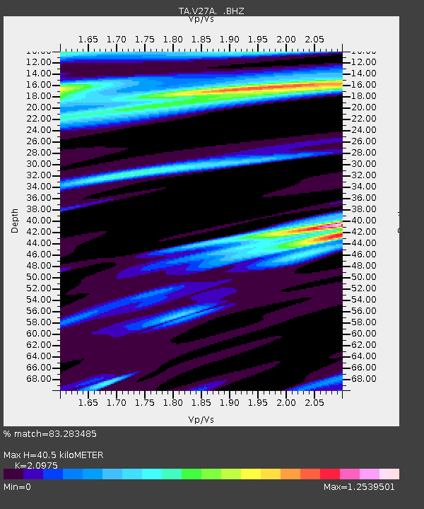
| Estimated Moho Depth: |
40.5 km |
| Estimated Crust Vp/Vs: |
2.10 |
| Assumed Crust Vp: |
6.242 km/s |
| Estimated Crust Vs: |
2.976 km/s |
| Estimated Crust Poisson's Ratio: |
0.35 |
|
| Radial Match: |
83.283485 % |
| Radial Bump: |
400 |
| Transverse Match: |
66.88423 % |
| Transverse Bump: |
394 |
| SOD ConfigId: |
307546 |
| Insert Time: |
2010-05-14 07:22:04.084 +0000 |
| GWidth: |
2.5 |
| Max Bumps: |
400 |
| Tol: |
0.001 |
|
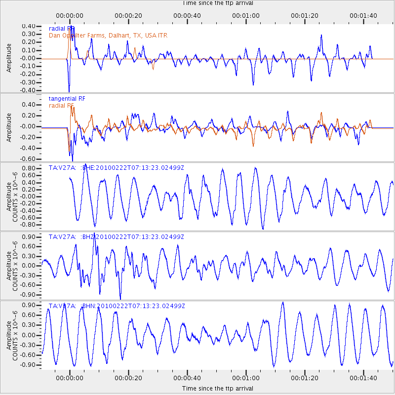
Signal To Noise
| Channel | StoN | STA | LTA |
| TA:V27A: :BHZ:20100222T07:13:23.02499Z | 1.8516991 | 3.4222236E-7 | 1.8481532E-7 |
| TA:V27A: :BHN:20100222T07:13:23.02499Z | 2.1402063 | 6.26477E-7 | 2.9271803E-7 |
| TA:V27A: :BHE:20100222T07:13:23.02499Z | 0.41719106 | 1.9085076E-7 | 4.5746606E-7 |
| Arrivals |
| Ps | 7.2 SECOND |
| PpPs | 20 SECOND |
| PsPs/PpSs | 27 SECOND |


