You are here: Home > Network List > TA - USArray Transportable Network (new EarthScope stations) Stations List
> Station P27A Ficken Ranch, Kirk, CO, USA > Earthquake Result Viewer
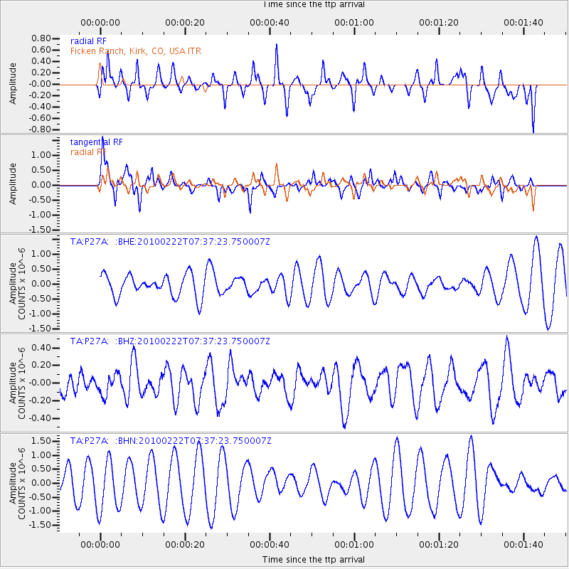
P27A Ficken Ranch, Kirk, CO, USA - Earthquake Result Viewer
*The percent match for this event was below the threshold and hence no stack was calculated.
| Earthquake location: |
Tonga Islands Region |
| Earthquake latitude/longitude: |
-23.7/-175.9 |
| Earthquake time(UTC): |
2010/02/22 (053) 07:24:45 GMT |
| Earthquake Depth: |
35 km |
| Earthquake Magnitude: |
5.6 MW, 5.2 MB |
| Earthquake Catalog/Contributor: |
WHDF/NEIC |
|
| Network: |
TA USArray Transportable Network (new EarthScope stations) |
| Station: |
P27A Ficken Ranch, Kirk, CO, USA |
| Lat/Lon: |
39.56 N/102.58 W |
| Elevation: |
1286 m |
|
| Distance: |
92.9 deg |
| Az: |
47.868 deg |
| Baz: |
241.528 deg |
| Ray Param: |
$rayparam |
*The percent match for this event was below the threshold and hence was not used in the summary stack. |
|
| Radial Match: |
68.351036 % |
| Radial Bump: |
362 |
| Transverse Match: |
59.423573 % |
| Transverse Bump: |
318 |
| SOD ConfigId: |
307546 |
| Insert Time: |
2010-05-14 07:33:21.351 +0000 |
| GWidth: |
2.5 |
| Max Bumps: |
400 |
| Tol: |
0.001 |
|
Signal To Noise
| Channel | StoN | STA | LTA |
| TA:P27A: :BHZ:20100222T07:37:23.750007Z | 0.590524 | 1.1511848E-7 | 1.9494291E-7 |
| TA:P27A: :BHN:20100222T07:37:23.750007Z | 3.0929966 | 9.135946E-7 | 2.9537523E-7 |
| TA:P27A: :BHE:20100222T07:37:23.750007Z | 0.560575 | 1.9969093E-7 | 3.5622517E-7 |
| Arrivals |
| Ps | |
| PpPs | |
| PsPs/PpSs | |


