You are here: Home > Network List > TX - Texas Seismological Network Stations List
> Station PB29 Culberson North > Earthquake Result Viewer
PB29 Culberson North - Earthquake Result Viewer
| Earthquake location: |
Near East Coast Of Kamchatka |
| Earthquake latitude/longitude: |
52.8/158.6 |
| Earthquake time(UTC): |
2023/04/03 (093) 03:06:55 GMT |
| Earthquake Depth: |
100 km |
| Earthquake Magnitude: |
6.7 Mi |
| Earthquake Catalog/Contributor: |
NEIC PDE/at |
|
| Network: |
TX Texas Seismological Network |
| Station: |
PB29 Culberson North |
| Lat/Lon: |
31.75 N/104.51 W |
| Elevation: |
1242 m |
|
| Distance: |
69.3 deg |
| Az: |
64.736 deg |
| Baz: |
319.867 deg |
| Ray Param: |
0.055512305 |
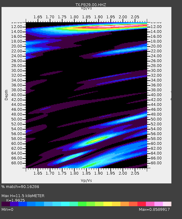
| Estimated Moho Depth: |
11.5 km |
| Estimated Crust Vp/Vs: |
1.96 |
| Assumed Crust Vp: |
6.361 km/s |
| Estimated Crust Vs: |
3.241 km/s |
| Estimated Crust Poisson's Ratio: |
0.32 |
|
| Radial Match: |
90.16286 % |
| Radial Bump: |
375 |
| Transverse Match: |
59.165565 % |
| Transverse Bump: |
362 |
| SOD ConfigId: |
30536071 |
| Insert Time: |
2023-04-17 03:38:08.432 +0000 |
| GWidth: |
2.5 |
| Max Bumps: |
400 |
| Tol: |
0.001 |
|

Signal To Noise
| Channel | StoN | STA | LTA |
| TX:PB29:00:HHZ:20230403T03:17:20.460022Z | 1.3730451 | 3.8655332E-7 | 2.8152996E-7 |
| TX:PB29:00:HH1:20230403T03:17:20.460022Z | 0.41135436 | 1.6963949E-7 | 4.123926E-7 |
| TX:PB29:00:HH2:20230403T03:17:20.460022Z | 0.96237844 | 1.9313673E-7 | 2.0068687E-7 |
| Arrivals |
| Ps | 1.8 SECOND |
| PpPs | 5.2 SECOND |
| PsPs/PpSs | 7.0 SECOND |


