You are here: Home > Network List > UO - University of Oregon Regional Network Stations List
> Station RSBO Finn Rock, OR, USA > Earthquake Result Viewer
RSBO Finn Rock, OR, USA - Earthquake Result Viewer
| Earthquake location: |
Near East Coast Of Kamchatka |
| Earthquake latitude/longitude: |
52.8/158.6 |
| Earthquake time(UTC): |
2023/04/03 (093) 03:06:55 GMT |
| Earthquake Depth: |
100 km |
| Earthquake Magnitude: |
6.7 Mi |
| Earthquake Catalog/Contributor: |
NEIC PDE/at |
|
| Network: |
UO University of Oregon Regional Network |
| Station: |
RSBO Finn Rock, OR, USA |
| Lat/Lon: |
44.04 N/122.27 W |
| Elevation: |
1235 m |
|
| Distance: |
50.7 deg |
| Az: |
66.183 deg |
| Baz: |
309.623 deg |
| Ray Param: |
0.06755891 |
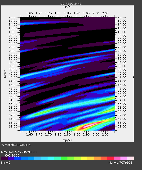
| Estimated Moho Depth: |
67.25 km |
| Estimated Crust Vp/Vs: |
1.96 |
| Assumed Crust Vp: |
6.566 km/s |
| Estimated Crust Vs: |
3.346 km/s |
| Estimated Crust Poisson's Ratio: |
0.32 |
|
| Radial Match: |
82.34386 % |
| Radial Bump: |
400 |
| Transverse Match: |
65.10611 % |
| Transverse Bump: |
400 |
| SOD ConfigId: |
30536071 |
| Insert Time: |
2023-04-17 03:39:08.180 +0000 |
| GWidth: |
2.5 |
| Max Bumps: |
400 |
| Tol: |
0.001 |
|

Signal To Noise
| Channel | StoN | STA | LTA |
| UO:RSBO: :HHZ:20230403T03:15:14.049988Z | 3.4200435 | 8.766374E-7 | 2.5632346E-7 |
| UO:RSBO: :HHN:20230403T03:15:14.049988Z | 2.4461768 | 6.3474505E-7 | 2.5948455E-7 |
| UO:RSBO: :HHE:20230403T03:15:14.049988Z | 1.3542933 | 5.5587674E-7 | 4.104552E-7 |
| Arrivals |
| Ps | 10 SECOND |
| PpPs | 29 SECOND |
| PsPs/PpSs | 39 SECOND |


