You are here: Home > Network List > TA - USArray Transportable Network (new EarthScope stations) Stations List
> Station V34A Guthrie, OK, USA > Earthquake Result Viewer
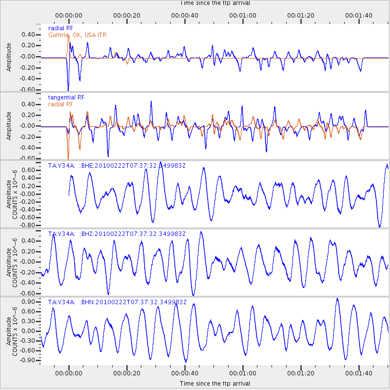
V34A Guthrie, OK, USA - Earthquake Result Viewer
*The percent match for this event was below the threshold and hence no stack was calculated.
| Earthquake location: |
Tonga Islands Region |
| Earthquake latitude/longitude: |
-23.7/-175.9 |
| Earthquake time(UTC): |
2010/02/22 (053) 07:24:45 GMT |
| Earthquake Depth: |
35 km |
| Earthquake Magnitude: |
5.6 MW, 5.2 MB |
| Earthquake Catalog/Contributor: |
WHDF/NEIC |
|
| Network: |
TA USArray Transportable Network (new EarthScope stations) |
| Station: |
V34A Guthrie, OK, USA |
| Lat/Lon: |
35.83 N/97.52 W |
| Elevation: |
329 m |
|
| Distance: |
94.8 deg |
| Az: |
53.013 deg |
| Baz: |
244.266 deg |
| Ray Param: |
$rayparam |
*The percent match for this event was below the threshold and hence was not used in the summary stack. |
|
| Radial Match: |
59.99374 % |
| Radial Bump: |
400 |
| Transverse Match: |
54.75159 % |
| Transverse Bump: |
313 |
| SOD ConfigId: |
307546 |
| Insert Time: |
2010-05-14 07:34:47.400 +0000 |
| GWidth: |
2.5 |
| Max Bumps: |
400 |
| Tol: |
0.001 |
|
Signal To Noise
| Channel | StoN | STA | LTA |
| TA:V34A: :BHZ:20100222T07:37:32.349983Z | 1.2935745 | 2.4564474E-7 | 1.8989611E-7 |
| TA:V34A: :BHN:20100222T07:37:32.349983Z | 0.72134125 | 2.1945054E-7 | 3.0422567E-7 |
| TA:V34A: :BHE:20100222T07:37:32.349983Z | 1.8152755 | 5.003878E-7 | 2.7565392E-7 |
| Arrivals |
| Ps | |
| PpPs | |
| PsPs/PpSs | |


