You are here: Home > Network List > AU - Australian Seismological Centre Stations List
> Station PSAA3 Pilbara Seismic Array Element A3 > Earthquake Result Viewer
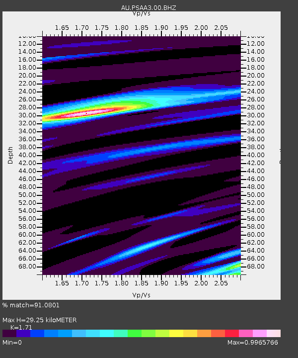
PSAA3 Pilbara Seismic Array Element A3 - Earthquake Result Viewer
| Earthquake location: |
Kuril Islands |
| Earthquake latitude/longitude: |
49.1/156.4 |
| Earthquake time(UTC): |
2018/10/10 (283) 23:16:04 GMT |
| Earthquake Depth: |
33 km |
| Earthquake Magnitude: |
6.8 Mi |
| Earthquake Catalog/Contributor: |
NEIC PDE/at |
|
| Network: |
AU Australian Seismological Centre |
| Station: |
PSAA3 Pilbara Seismic Array Element A3 |
| Lat/Lon: |
21.58 S/119.85 E |
| Elevation: |
315 m |
|
| Distance: |
77.5 deg |
| Az: |
214.584 deg |
| Baz: |
23.629 deg |
| Ray Param: |
0.050212204 |
| Estimated Moho Depth: |
29.25 km |
| Estimated Crust Vp/Vs: |
1.71 |
| Assumed Crust Vp: |
6.464 km/s |
| Estimated Crust Vs: |
3.78 km/s |
| Estimated Crust Poisson's Ratio: |
0.24 |
|
| Radial Match: |
91.0801 % |
| Radial Bump: |
384 |
| Transverse Match: |
73.001114 % |
| Transverse Bump: |
400 |
| SOD ConfigId: |
3045211 |
| Insert Time: |
2018-10-24 23:25:59.151 +0000 |
| GWidth: |
2.5 |
| Max Bumps: |
400 |
| Tol: |
0.001 |
|

Signal To Noise
| Channel | StoN | STA | LTA |
| AU:PSAA3:00:BHZ:20181010T23:27:25.393982Z | 7.121656 | 1.8694193E-6 | 2.6249782E-7 |
| AU:PSAA3:00:BH1:20181010T23:27:25.393982Z | 2.8947306 | 6.656016E-7 | 2.299356E-7 |
| AU:PSAA3:00:BH2:20181010T23:27:25.393982Z | 2.3511837 | 3.8078642E-7 | 1.619552E-7 |
| Arrivals |
| Ps | 3.3 SECOND |
| PpPs | 12 SECOND |
| PsPs/PpSs | 15 SECOND |


