You are here: Home > Network List > US - United States National Seismic Network Stations List
> Station WMOK Wichita Mountains, Oklahoma, USA > Earthquake Result Viewer
WMOK Wichita Mountains, Oklahoma, USA - Earthquake Result Viewer
*The percent match for this event was below the threshold and hence no stack was calculated.
| Earthquake location: |
Near East Coast Of Kamchatka |
| Earthquake latitude/longitude: |
52.8/158.6 |
| Earthquake time(UTC): |
2023/04/03 (093) 03:06:55 GMT |
| Earthquake Depth: |
100 km |
| Earthquake Magnitude: |
6.7 Mi |
| Earthquake Catalog/Contributor: |
NEIC PDE/at |
|
| Network: |
US United States National Seismic Network |
| Station: |
WMOK Wichita Mountains, Oklahoma, USA |
| Lat/Lon: |
34.74 N/98.78 W |
| Elevation: |
486 m |
|
| Distance: |
70.0 deg |
| Az: |
58.766 deg |
| Baz: |
320.92 deg |
| Ray Param: |
$rayparam |
*The percent match for this event was below the threshold and hence was not used in the summary stack. |
|
| Radial Match: |
65.40529 % |
| Radial Bump: |
400 |
| Transverse Match: |
63.37013 % |
| Transverse Bump: |
400 |
| SOD ConfigId: |
30536071 |
| Insert Time: |
2023-04-17 03:40:11.087 +0000 |
| GWidth: |
2.5 |
| Max Bumps: |
400 |
| Tol: |
0.001 |
|
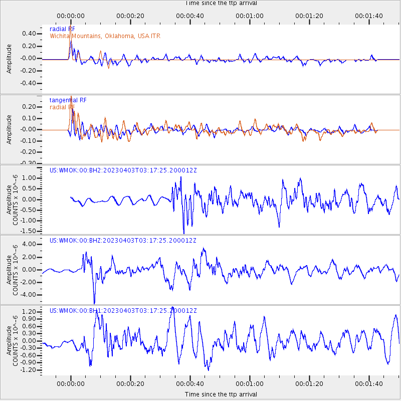
Signal To Noise
| Channel | StoN | STA | LTA |
| US:WMOK:00:BHZ:20230403T03:17:25.200012Z | 3.0532553 | 6.4541337E-7 | 2.1138533E-7 |
| US:WMOK:00:BH1:20230403T03:17:25.200012Z | 1.0697919 | 2.3655106E-7 | 2.2111877E-7 |
| US:WMOK:00:BH2:20230403T03:17:25.200012Z | 1.7347075 | 1.9660983E-7 | 1.1333889E-7 |
| Arrivals |
| Ps | |
| PpPs | |
| PsPs/PpSs | |


