You are here: Home > Network List > UW - Pacific Northwest Regional Seismic Network Stations List
> Station DATON Dayton, WA, USA > Earthquake Result Viewer
DATON Dayton, WA, USA - Earthquake Result Viewer
| Earthquake location: |
Near East Coast Of Kamchatka |
| Earthquake latitude/longitude: |
52.8/158.6 |
| Earthquake time(UTC): |
2023/04/03 (093) 03:06:55 GMT |
| Earthquake Depth: |
100 km |
| Earthquake Magnitude: |
6.7 Mi |
| Earthquake Catalog/Contributor: |
NEIC PDE/at |
|
| Network: |
UW Pacific Northwest Regional Seismic Network |
| Station: |
DATON Dayton, WA, USA |
| Lat/Lon: |
46.26 N/117.93 W |
| Elevation: |
815 m |
|
| Distance: |
51.7 deg |
| Az: |
61.475 deg |
| Baz: |
309.74 deg |
| Ray Param: |
0.06693703 |
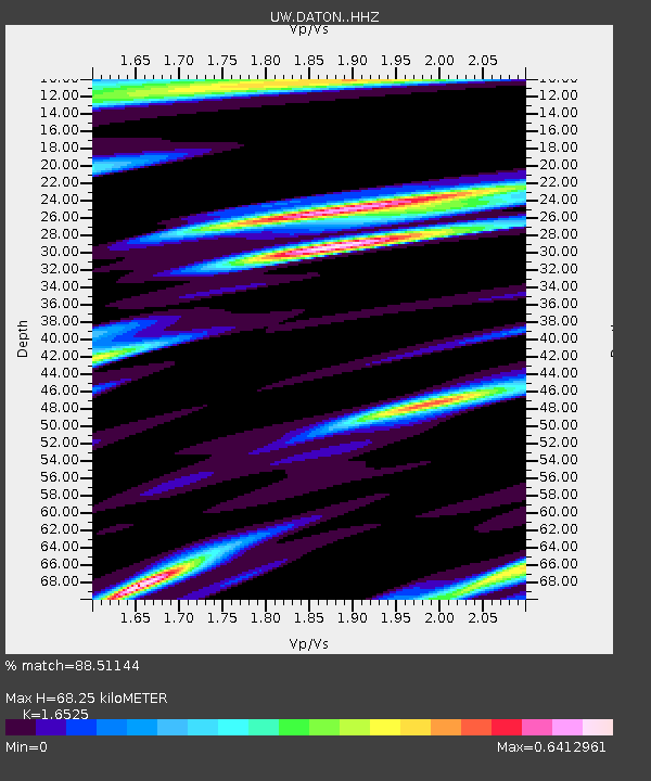
| Estimated Moho Depth: |
68.25 km |
| Estimated Crust Vp/Vs: |
1.65 |
| Assumed Crust Vp: |
6.571 km/s |
| Estimated Crust Vs: |
3.976 km/s |
| Estimated Crust Poisson's Ratio: |
0.21 |
|
| Radial Match: |
88.51144 % |
| Radial Bump: |
343 |
| Transverse Match: |
72.89268 % |
| Transverse Bump: |
400 |
| SOD ConfigId: |
30536071 |
| Insert Time: |
2023-04-17 03:41:01.400 +0000 |
| GWidth: |
2.5 |
| Max Bumps: |
400 |
| Tol: |
0.001 |
|

Signal To Noise
| Channel | StoN | STA | LTA |
| UW:DATON: :HHZ:20230403T03:15:21.119995Z | 2.944513 | 7.8736997E-7 | 2.674024E-7 |
| UW:DATON: :HHN:20230403T03:15:21.119995Z | 1.6098276 | 2.946861E-7 | 1.8305444E-7 |
| UW:DATON: :HHE:20230403T03:15:21.119995Z | 1.915954 | 3.5158803E-7 | 1.8350546E-7 |
| Arrivals |
| Ps | 7.2 SECOND |
| PpPs | 26 SECOND |
| PsPs/PpSs | 33 SECOND |


