You are here: Home > Network List > UW - Pacific Northwest Regional Seismic Network Stations List
> Station RER Emerald Ridge, Mount Rainier, WA, USA > Earthquake Result Viewer
RER Emerald Ridge, Mount Rainier, WA, USA - Earthquake Result Viewer
| Earthquake location: |
Near East Coast Of Kamchatka |
| Earthquake latitude/longitude: |
52.8/158.6 |
| Earthquake time(UTC): |
2023/04/03 (093) 03:06:55 GMT |
| Earthquake Depth: |
100 km |
| Earthquake Magnitude: |
6.7 Mi |
| Earthquake Catalog/Contributor: |
NEIC PDE/at |
|
| Network: |
UW Pacific Northwest Regional Seismic Network |
| Station: |
RER Emerald Ridge, Mount Rainier, WA, USA |
| Lat/Lon: |
46.82 N/121.84 W |
| Elevation: |
1751 m |
|
| Distance: |
49.2 deg |
| Az: |
63.113 deg |
| Baz: |
307.95 deg |
| Ray Param: |
0.06853382 |
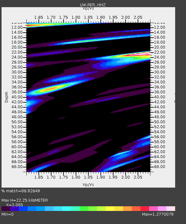
| Estimated Moho Depth: |
22.25 km |
| Estimated Crust Vp/Vs: |
2.09 |
| Assumed Crust Vp: |
6.597 km/s |
| Estimated Crust Vs: |
3.164 km/s |
| Estimated Crust Poisson's Ratio: |
0.35 |
|
| Radial Match: |
86.92649 % |
| Radial Bump: |
400 |
| Transverse Match: |
64.84704 % |
| Transverse Bump: |
400 |
| SOD ConfigId: |
30536071 |
| Insert Time: |
2023-04-17 03:42:53.595 +0000 |
| GWidth: |
2.5 |
| Max Bumps: |
400 |
| Tol: |
0.001 |
|

Signal To Noise
| Channel | StoN | STA | LTA |
| UW:RER: :HHZ:20230403T03:15:02.690002Z | 2.4787967 | 5.7178374E-7 | 2.306699E-7 |
| UW:RER: :HHN:20230403T03:15:02.690002Z | 1.8001678 | 3.9197027E-7 | 2.1774096E-7 |
| UW:RER: :HHE:20230403T03:15:02.690002Z | 1.1911886 | 2.9344952E-7 | 2.463502E-7 |
| Arrivals |
| Ps | 3.9 SECOND |
| PpPs | 9.9 SECOND |
| PsPs/PpSs | 14 SECOND |


