You are here: Home > Network List > UW - Pacific Northwest Regional Seismic Network Stations List
> Station SHW Mt. St. Helens West, WA, USA > Earthquake Result Viewer
SHW Mt. St. Helens West, WA, USA - Earthquake Result Viewer
| Earthquake location: |
Near East Coast Of Kamchatka |
| Earthquake latitude/longitude: |
52.8/158.6 |
| Earthquake time(UTC): |
2023/04/03 (093) 03:06:55 GMT |
| Earthquake Depth: |
100 km |
| Earthquake Magnitude: |
6.7 Mi |
| Earthquake Catalog/Contributor: |
NEIC PDE/at |
|
| Network: |
UW Pacific Northwest Regional Seismic Network |
| Station: |
SHW Mt. St. Helens West, WA, USA |
| Lat/Lon: |
46.19 N/122.23 W |
| Elevation: |
1442 m |
|
| Distance: |
49.4 deg |
| Az: |
63.982 deg |
| Baz: |
308.233 deg |
| Ray Param: |
0.06842028 |
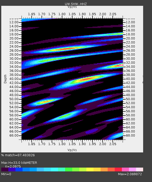
| Estimated Moho Depth: |
33.0 km |
| Estimated Crust Vp/Vs: |
2.10 |
| Assumed Crust Vp: |
6.566 km/s |
| Estimated Crust Vs: |
3.13 km/s |
| Estimated Crust Poisson's Ratio: |
0.35 |
|
| Radial Match: |
87.483826 % |
| Radial Bump: |
400 |
| Transverse Match: |
82.46266 % |
| Transverse Bump: |
400 |
| SOD ConfigId: |
30536071 |
| Insert Time: |
2023-04-17 03:43:05.265 +0000 |
| GWidth: |
2.5 |
| Max Bumps: |
400 |
| Tol: |
0.001 |
|

Signal To Noise
| Channel | StoN | STA | LTA |
| UW:SHW: :HHZ:20230403T03:15:04.000Z | 2.3415225 | 6.8930353E-7 | 2.9438263E-7 |
| UW:SHW: :HHN:20230403T03:15:04.000Z | 0.5976396 | 3.9969424E-7 | 6.687881E-7 |
| UW:SHW: :HHE:20230403T03:15:04.000Z | 0.86176807 | 4.3754113E-7 | 5.0772496E-7 |
| Arrivals |
| Ps | 5.8 SECOND |
| PpPs | 15 SECOND |
| PsPs/PpSs | 21 SECOND |


