You are here: Home > Network List > TA - USArray Transportable Network (new EarthScope stations) Stations List
> Station A26A Wade Farm, Kenmare, ND, USA > Earthquake Result Viewer
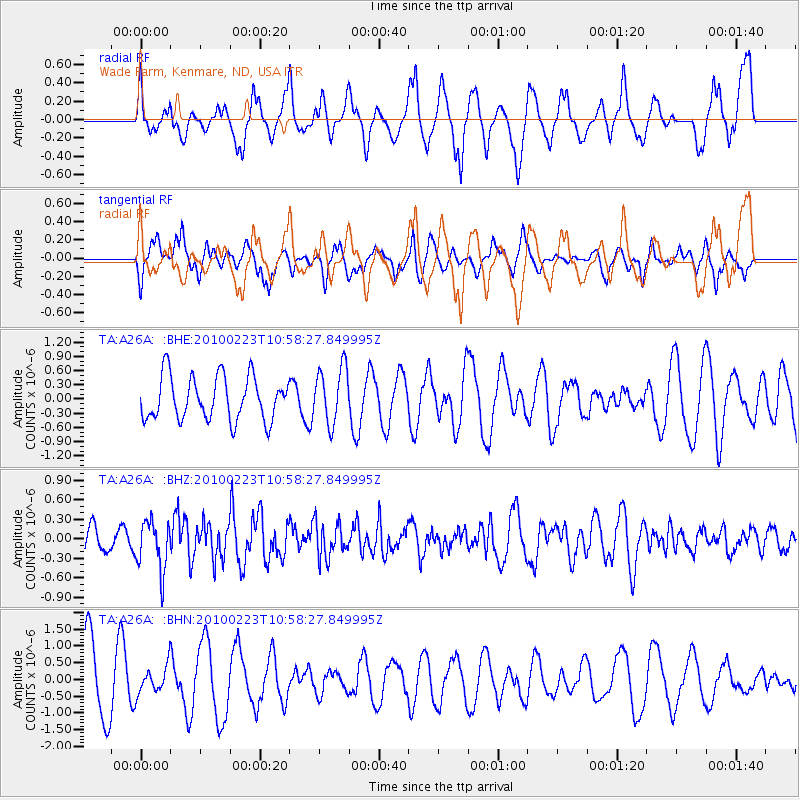
A26A Wade Farm, Kenmare, ND, USA - Earthquake Result Viewer
*The percent match for this event was below the threshold and hence no stack was calculated.
| Earthquake location: |
Mexico-Guatemala Border Region |
| Earthquake latitude/longitude: |
15.9/-91.2 |
| Earthquake time(UTC): |
2010/02/23 (054) 10:52:13 GMT |
| Earthquake Depth: |
9.1 km |
| Earthquake Magnitude: |
5.5 MD, 5.3 MW, 5.2 MB |
| Earthquake Catalog/Contributor: |
WHDF/NEIC |
|
| Network: |
TA USArray Transportable Network (new EarthScope stations) |
| Station: |
A26A Wade Farm, Kenmare, ND, USA |
| Lat/Lon: |
48.90 N/102.04 W |
| Elevation: |
570 m |
|
| Distance: |
34.1 deg |
| Az: |
347.213 deg |
| Baz: |
161.173 deg |
| Ray Param: |
$rayparam |
*The percent match for this event was below the threshold and hence was not used in the summary stack. |
|
| Radial Match: |
36.37943 % |
| Radial Bump: |
333 |
| Transverse Match: |
50.123318 % |
| Transverse Bump: |
361 |
| SOD ConfigId: |
307546 |
| Insert Time: |
2010-05-14 07:40:09.092 +0000 |
| GWidth: |
2.5 |
| Max Bumps: |
400 |
| Tol: |
0.001 |
|
Signal To Noise
| Channel | StoN | STA | LTA |
| TA:A26A: :BHZ:20100223T10:58:27.849995Z | 1.7430393 | 3.8327107E-7 | 2.1988666E-7 |
| TA:A26A: :BHN:20100223T10:58:27.849995Z | 0.4533763 | 4.0203756E-7 | 8.8676353E-7 |
| TA:A26A: :BHE:20100223T10:58:27.849995Z | 1.2997558 | 5.9482664E-7 | 4.5764492E-7 |
| Arrivals |
| Ps | |
| PpPs | |
| PsPs/PpSs | |


