You are here: Home > Network List > UW - Pacific Northwest Regional Seismic Network Stations List
> Station WOLL Wollman Farm, Schrag, WA, USA > Earthquake Result Viewer
WOLL Wollman Farm, Schrag, WA, USA - Earthquake Result Viewer
| Earthquake location: |
Near East Coast Of Kamchatka |
| Earthquake latitude/longitude: |
52.8/158.6 |
| Earthquake time(UTC): |
2023/04/03 (093) 03:06:55 GMT |
| Earthquake Depth: |
100 km |
| Earthquake Magnitude: |
6.7 Mi |
| Earthquake Catalog/Contributor: |
NEIC PDE/at |
|
| Network: |
UW Pacific Northwest Regional Seismic Network |
| Station: |
WOLL Wollman Farm, Schrag, WA, USA |
| Lat/Lon: |
47.06 N/118.92 W |
| Elevation: |
385 m |
|
| Distance: |
50.6 deg |
| Az: |
61.243 deg |
| Baz: |
308.874 deg |
| Ray Param: |
0.06761315 |
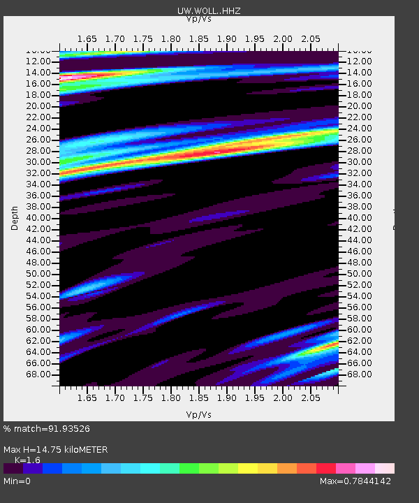
| Estimated Moho Depth: |
14.75 km |
| Estimated Crust Vp/Vs: |
1.60 |
| Assumed Crust Vp: |
6.419 km/s |
| Estimated Crust Vs: |
4.012 km/s |
| Estimated Crust Poisson's Ratio: |
0.18 |
|
| Radial Match: |
91.93526 % |
| Radial Bump: |
400 |
| Transverse Match: |
65.371155 % |
| Transverse Bump: |
400 |
| SOD ConfigId: |
30536071 |
| Insert Time: |
2023-04-17 03:43:43.149 +0000 |
| GWidth: |
2.5 |
| Max Bumps: |
400 |
| Tol: |
0.001 |
|

Signal To Noise
| Channel | StoN | STA | LTA |
| UW:WOLL: :HHZ:20230403T03:15:13.410004Z | 4.0638556 | 1.0006311E-6 | 2.4622702E-7 |
| UW:WOLL: :HHN:20230403T03:15:13.410004Z | 1.7080466 | 3.2778797E-7 | 1.919081E-7 |
| UW:WOLL: :HHE:20230403T03:15:13.410004Z | 1.3569632 | 3.684237E-7 | 2.7150605E-7 |
| Arrivals |
| Ps | 1.5 SECOND |
| PpPs | 5.6 SECOND |
| PsPs/PpSs | 7.1 SECOND |


