You are here: Home > Network List > GS - US Geological Survey Networks Stations List
> Station DEC04 Decatur Surface Seismic Site, Decatur, IL, USA > Earthquake Result Viewer
DEC04 Decatur Surface Seismic Site, Decatur, IL, USA - Earthquake Result Viewer
| Earthquake location: |
Kuril Islands |
| Earthquake latitude/longitude: |
49.1/156.4 |
| Earthquake time(UTC): |
2018/10/10 (283) 23:16:04 GMT |
| Earthquake Depth: |
33 km |
| Earthquake Magnitude: |
6.8 Mi |
| Earthquake Catalog/Contributor: |
NEIC PDE/at |
|
| Network: |
GS US Geological Survey Networks |
| Station: |
DEC04 Decatur Surface Seismic Site, Decatur, IL, USA |
| Lat/Lon: |
39.88 N/88.86 W |
| Elevation: |
225 m |
|
| Distance: |
74.4 deg |
| Az: |
46.533 deg |
| Baz: |
321.692 deg |
| Ray Param: |
0.05234 |
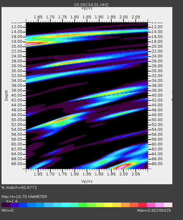
| Estimated Moho Depth: |
18.75 km |
| Estimated Crust Vp/Vs: |
1.60 |
| Assumed Crust Vp: |
6.444 km/s |
| Estimated Crust Vs: |
4.027 km/s |
| Estimated Crust Poisson's Ratio: |
0.18 |
|
| Radial Match: |
80.8772 % |
| Radial Bump: |
400 |
| Transverse Match: |
27.429995 % |
| Transverse Bump: |
400 |
| SOD ConfigId: |
3045211 |
| Insert Time: |
2018-10-24 23:27:37.990 +0000 |
| GWidth: |
2.5 |
| Max Bumps: |
400 |
| Tol: |
0.001 |
|

Signal To Noise
| Channel | StoN | STA | LTA |
| GS:DEC04:01:HHZ:20181010T23:27:07.343994Z | 4.04312 | 2.323932E-6 | 5.747868E-7 |
| GS:DEC04:01:HHN:20181010T23:27:07.343994Z | 0.6912485 | 1.1646182E-6 | 1.6848041E-6 |
| GS:DEC04:01:HHE:20181010T23:27:07.343994Z | 0.632144 | 1.1443481E-6 | 1.8102648E-6 |
| Arrivals |
| Ps | 1.8 SECOND |
| PpPs | 7.3 SECOND |
| PsPs/PpSs | 9.1 SECOND |


