You are here: Home > Network List > AK - Alaska Regional Network Stations List
> Station O18K Koktuh Hills, AK, USA > Earthquake Result Viewer
O18K Koktuh Hills, AK, USA - Earthquake Result Viewer
| Earthquake location: |
Philippine Islands Region |
| Earthquake latitude/longitude: |
13.8/125.5 |
| Earthquake time(UTC): |
2023/04/04 (094) 12:54:32 GMT |
| Earthquake Depth: |
15 km |
| Earthquake Magnitude: |
6.2 mww |
| Earthquake Catalog/Contributor: |
NEIC PDE/us |
|
| Network: |
AK Alaska Regional Network |
| Station: |
O18K Koktuh Hills, AK, USA |
| Lat/Lon: |
59.85 N/155.21 W |
| Elevation: |
544 m |
|
| Distance: |
72.8 deg |
| Az: |
31.268 deg |
| Baz: |
267.768 deg |
| Ray Param: |
0.053412914 |
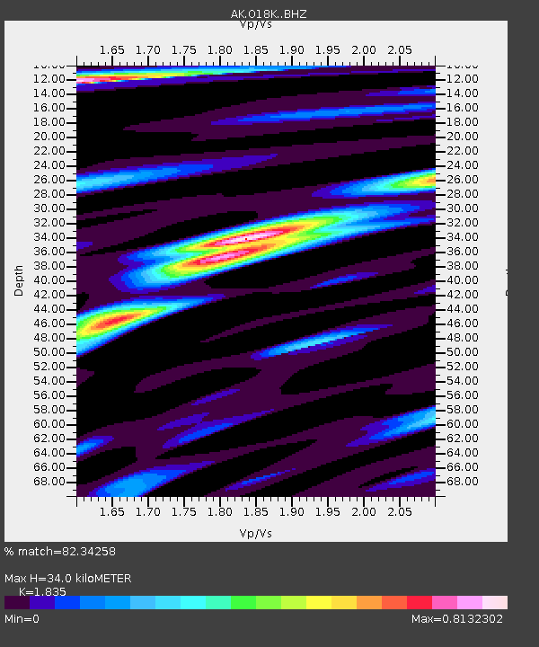
| Estimated Moho Depth: |
34.0 km |
| Estimated Crust Vp/Vs: |
1.84 |
| Assumed Crust Vp: |
6.438 km/s |
| Estimated Crust Vs: |
3.509 km/s |
| Estimated Crust Poisson's Ratio: |
0.29 |
|
| Radial Match: |
82.34258 % |
| Radial Bump: |
367 |
| Transverse Match: |
72.6242 % |
| Transverse Bump: |
365 |
| SOD ConfigId: |
30536071 |
| Insert Time: |
2023-04-18 12:57:30.156 +0000 |
| GWidth: |
2.5 |
| Max Bumps: |
400 |
| Tol: |
0.001 |
|

Signal To Noise
| Channel | StoN | STA | LTA |
| AK:O18K: :BHZ:20230404T13:05:29.199985Z | 3.718958 | 4.1184813E-7 | 1.1074288E-7 |
| AK:O18K: :BHN:20230404T13:05:29.199985Z | 0.93370885 | 2.502119E-7 | 2.6797636E-7 |
| AK:O18K: :BHE:20230404T13:05:29.199985Z | 2.1346307 | 3.0814306E-7 | 1.4435427E-7 |
| Arrivals |
| Ps | 4.6 SECOND |
| PpPs | 14 SECOND |
| PsPs/PpSs | 19 SECOND |


