You are here: Home > Network List > NE - New England Seismic Network Stations List
> Station VT1 Waterbury, VT, USA > Earthquake Result Viewer
VT1 Waterbury, VT, USA - Earthquake Result Viewer
| Earthquake location: |
Kuril Islands |
| Earthquake latitude/longitude: |
49.1/156.4 |
| Earthquake time(UTC): |
2018/10/10 (283) 23:16:04 GMT |
| Earthquake Depth: |
33 km |
| Earthquake Magnitude: |
6.8 Mi |
| Earthquake Catalog/Contributor: |
NEIC PDE/at |
|
| Network: |
NE New England Seismic Network |
| Station: |
VT1 Waterbury, VT, USA |
| Lat/Lon: |
44.32 N/72.75 W |
| Elevation: |
149 m |
|
| Distance: |
77.5 deg |
| Az: |
33.787 deg |
| Baz: |
329.389 deg |
| Ray Param: |
0.050224088 |
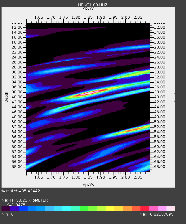
| Estimated Moho Depth: |
38.25 km |
| Estimated Crust Vp/Vs: |
1.85 |
| Assumed Crust Vp: |
6.419 km/s |
| Estimated Crust Vs: |
3.475 km/s |
| Estimated Crust Poisson's Ratio: |
0.29 |
|
| Radial Match: |
85.43442 % |
| Radial Bump: |
400 |
| Transverse Match: |
76.460625 % |
| Transverse Bump: |
400 |
| SOD ConfigId: |
3045211 |
| Insert Time: |
2018-10-24 23:29:57.367 +0000 |
| GWidth: |
2.5 |
| Max Bumps: |
400 |
| Tol: |
0.001 |
|

Signal To Noise
| Channel | StoN | STA | LTA |
| NE:VT1:00:HHZ:20181010T23:27:25.294006Z | 6.328847 | 2.3361813E-6 | 3.691322E-7 |
| NE:VT1:00:HH1:20181010T23:27:25.294006Z | 3.846292 | 1.1140843E-6 | 2.896515E-7 |
| NE:VT1:00:HH2:20181010T23:27:25.294006Z | 2.614464 | 7.9299986E-7 | 3.0331256E-7 |
| Arrivals |
| Ps | 5.2 SECOND |
| PpPs | 16 SECOND |
| PsPs/PpSs | 22 SECOND |


