You are here: Home > Network List > AU - Australian Seismological Centre Stations List
> Station PSAD3 Pilbara Seismic Array Element D3 > Earthquake Result Viewer
PSAD3 Pilbara Seismic Array Element D3 - Earthquake Result Viewer
| Earthquake location: |
Philippine Islands Region |
| Earthquake latitude/longitude: |
13.8/125.5 |
| Earthquake time(UTC): |
2023/04/04 (094) 12:54:32 GMT |
| Earthquake Depth: |
15 km |
| Earthquake Magnitude: |
6.2 mww |
| Earthquake Catalog/Contributor: |
NEIC PDE/us |
|
| Network: |
AU Australian Seismological Centre |
| Station: |
PSAD3 Pilbara Seismic Array Element D3 |
| Lat/Lon: |
21.64 S/119.78 E |
| Elevation: |
327 m |
|
| Distance: |
35.6 deg |
| Az: |
189.225 deg |
| Baz: |
9.638 deg |
| Ray Param: |
0.077110514 |
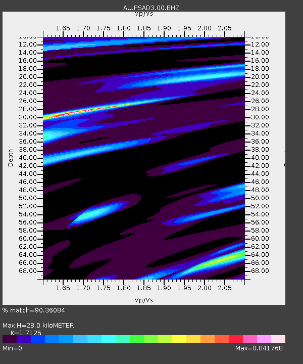
| Estimated Moho Depth: |
28.0 km |
| Estimated Crust Vp/Vs: |
1.71 |
| Assumed Crust Vp: |
6.464 km/s |
| Estimated Crust Vs: |
3.774 km/s |
| Estimated Crust Poisson's Ratio: |
0.24 |
|
| Radial Match: |
90.36084 % |
| Radial Bump: |
313 |
| Transverse Match: |
70.74088 % |
| Transverse Bump: |
400 |
| SOD ConfigId: |
30536071 |
| Insert Time: |
2023-04-18 12:59:26.587 +0000 |
| GWidth: |
2.5 |
| Max Bumps: |
400 |
| Tol: |
0.001 |
|

Signal To Noise
| Channel | StoN | STA | LTA |
| AU:PSAD3:00:BHZ:20230404T13:00:58.91901Z | 9.373229 | 1.9010711E-6 | 2.0281922E-7 |
| AU:PSAD3:00:BH1:20230404T13:00:58.91901Z | 8.561911 | 9.172978E-7 | 1.0713705E-7 |
| AU:PSAD3:00:BH2:20230404T13:00:58.91901Z | 4.4554925 | 5.733454E-7 | 1.2868283E-7 |
| Arrivals |
| Ps | 3.3 SECOND |
| PpPs | 11 SECOND |
| PsPs/PpSs | 14 SECOND |


